McCaffery Fire east of Redmond Airport 100% contained; Level 1 Be Ready evacuation alerts being lifted
(Update: Level 1 Be Ready evacuation notices being lifted; Crook County SO news release)
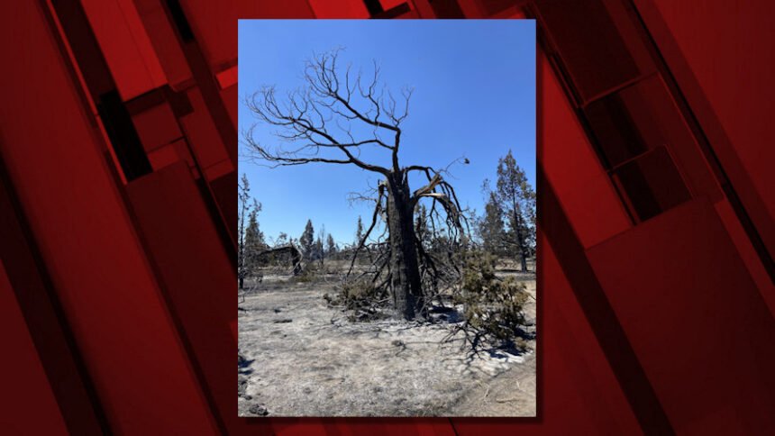
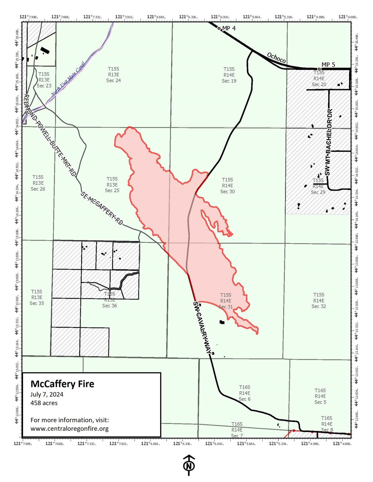
REDMOND, Ore. (KTVZ) – Firefighters working to secure lines in more record-breaking heat brought the now 4-day-old 458-acre McCaffery Fire east of Redmond Airport to 100% containment Tuesday, after the Deschutes and Crook county sheriff's offices dropped evacuation levels further Tuesday morning, to Level 1 Be Ready. And they said Thursday those will be lifted in the evening.
*****Update July 11, 2024 12:00 PM*****
After consultation with fire managers, the Deschutes County Sheriff's Office and Crook County Sheriff’s Office are lifting all evacuation notices around the McCaffery Fire effective at 5:00pm today.
Updated maps and information can be found at deschutes.org/emergency.
Please continue to be engaged and vigilant of what is happening in your surrounding areas.
Please refer to the Prineville District of the Bureau of Land Management for information regarding road and area closures.
--
News release Thursday from the Crook County Sheriff's Office:
As of 5:00 pm today (7-11-24), all fire warning notices for the McCaffery Fire area in Crook County, Oregon, will be lifted. Crews have worked hard and made good progress on mopping up activities. All seasonal fire restrictions remain in place.
The Crook County Sheriff’s Office would like to thank all our partners during this time of crisis.
Thanks go out to:
Crook County Fire and Rescue,
Redmond Fire,
Deschutes County Sheriff’s Department,
Oregon State Police
American Red Cross,
BLM Fire Crews,
BLM Law Enforcement,
Central Oregon Interagency Type Three Team
Crook County Sheriff Search and Rescue
And
A special thanks to the Powell Butte Church, who quickly and willingly opened their facility to those in need.
All of these partners worked tirelessly to bring the situation to a safe conclusion. The Crook County Sheriff’s Office would again like to remind everyone that it is summer in Central Oregon. This year, the wild grasses are tall and drying rapidly. These fuels combust easily and spread fire rapidly. Think before you go into the countryside. Be smart, and don’t create the spark that sets a wildfire in motion
Here's the Wednesday morning update from fire officials:
Yesterday, firefighters on the McCaffery Fire east of Redmond spent a successful day further securing the fire and addressing hot spots. The McCaffery Fire remains 458 acres and is now 100% contained. This will be the last update unless significant changes occur.
Yesterday at 7 p.m., the Central Oregon Type 3 incident management team transferred command to a local Type 4 incident commander as the Type 3 team received reassignment to an emerging incident. Several resources will remain on the incident following the transition to ensure the fire stays within its current footprint. Resources assigned include 14 engines, 1 Type 2 crew, 4 water tenders, 1 skidgeon, 1 dozer and overhead resources.
The fire is burning on Prineville District Bureau of Land Management (BLM) lands. The BLM has implemented a temporary area closure for the safety of the public and the firefighters working to contain the McCaffery Fire. To read the closure order in its entirety, visit: Prineville District BLM Temporary Area Closure.
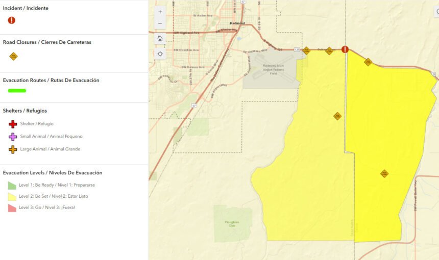
Yesterday, the Deschutes County Sheriff’s Office lowered the evacuation notice for the areas on Sunny Sage Road off of McCaffery Road to a Level 1 “Be Ready.” The Crook County Sheriff’s Office reduced the evacuation level for the area of west Powell Butte Estates and the area to the south of Powell Butte Highway in Crook County to a Level 1 “Be Ready.” Setay up to date on Crook County Emergency Alerts by visiting: alertcrookcounty.org/ To sign-up for Deschutes County Emergency Alerts visit: deschutes.org/911/page/sign-deschutes-alerts.
The cause of the fire is under investigation.
For current wildfire information, the public can visit centraloregonfire.org or follow fire information on X (Twitter) @CentralORFire.
"Firefighters on the #McCafferyFire made excellent progress today, increasing containment to 100%," officials said Tuesday night. "Transfer of command from Type 3 team to local IC (Incident Command) 4 occurred at 7 p.m. today as Type 3 team reassigned to emerging incident. Several resources remain on the fire to continue securing."
--
Tuesday morning update from the Deschutes County Sheriff's Office:
Released by: Sergeant Nathan Garibay
Date: July 9, 2024
Location: McCaffery Fire
UPDATE July 9, 2024 08:30 AM *****
Due to continued progress on the McCaffery Fire, both Deschutes County Sheriff's Office and Crook County Sheriff's Office are reducing evacuation levels from Level 2: Be Set to Level 1: Be Ready for the following areas:
Level 2: Be Set has been reduced to Level 1: Be Ready for the areas on Sunny Sage Rd. off of McCaffery Rd. in Deschutes County
Level 2: Be Set has been reduced to Level 1: Be Ready for the area of west Powell Butte Estates and the area to the south to Powell Butte Hwy. in Crook County.
Level 1: Be Ready means you should be ready to evacuate if conditions worsen. Stay informed and monitor local media, official news and social media sites, and prepare your vehicle and family for evacuation.
Current evacuation maps can be found at www.deschutes.org/emergency.
Residents and landowners on Sunny Sage and SE McCaffery Rd in Deschutes County will only be able to access their property via Sherman Rd from Hwy 126 (just past the Redmond Airport). Residents and landowners please only travel on Sherman Rd to McCaffery to Sunny Sage.
Please do not travel on any roads other than Sherman Rd, McCaffery, and Sunny Sage. McCaffery Rd is closed east of Sunny Sage.
--
Tuesday morning Release from Crook County Sheriff's Office:
All areas of Crook County affected by the McCaffery fire are now at Level One while mop-up operations are taking place. The Crook County Sheriff’s Office would like to remind everyone that the fire danger is very high and likely will remain so for the foreseeable future. Please think about your behavior in terms of fire risk. Please follow all applicable fire restrictions and see if you can be even safer than that. Let's not risk our neighbor's safety, our firefighter’s safety, and property loss for one moment of carelessness.
--
Earlier information:
Redmond set a record for the date once again Monday, reaching 104 degrees, one degree higher than the reading in 1968. Tuesday could be even hotter.
Both evacuation zones were dropped to Level 2 Be Set by late Sunday, but the BLM imposed an area closure, limiting access routes for returning residents and landowners.
Residents forced to evacuate Saturday as the fire grew fast were able to return home Sunday morning.
"We were out west of Redmond and got a text from some friends who the text said, 'Bring your family and your animals here," Powell Butte resident Jensine Peterson said Monday. "Which was just so such an odd text to get - but it was within a second, you kind of understand what that means."
On Monday morning, West Powell Butte Estates, an area evacuated in Crook County, showed no signs of any damage as residents counted their blessings and expressed gratitude.
"We're certainly concerned about our space," Peterson said. "We want to know that our neighbors and everybody else is okay, too. I feel like the community was able to sigh just a little, but together, we we feel like we're we're in good hands."
"Firefighters caught a few spot fires outside of containment lines today (Sunday) but held all fires at under an acre, with the support of helicopters cooling hot spots," officials said early Sunday evening on the Central Oregon Fire X/Twitter feed.
Sunday's progress came despite Redmond breaking a July 7th temperature record, as it reached 103 degrees, smashing the old record of 100 degrees set in 1968. An excessive heat warning is in place through Wednesday night for much of the region, as well as a red flag warning of fire danger until Tuesday night.
Meanwhile, the Deschutes County Sheriff's Office on Monday lifted the last evacuation levels around the nearly 2-week-old Darlene 3 Fire near La Pine, which was fully contained last week at nearly 4,000 acres. Lieutenant Jayson Janes noted that numerous road and area closures are still in place around that fire. Evacuation information on Deschutes County fires can be found in a map at www.deschutes.org/emergency.
Earlier Sunday, they said the blaze had burned 458 acres and was 10% contained; the acreage held steady through the day.
Tyler Knight, the Central Oregon Fire Management Service's incident commander trainee, talked with us Sunday about the fire's start.
"Once we got on scene, the fire started growing rapidly, had some torching, some spotting, light flashy fuel," he said. "It moved quickly on us."
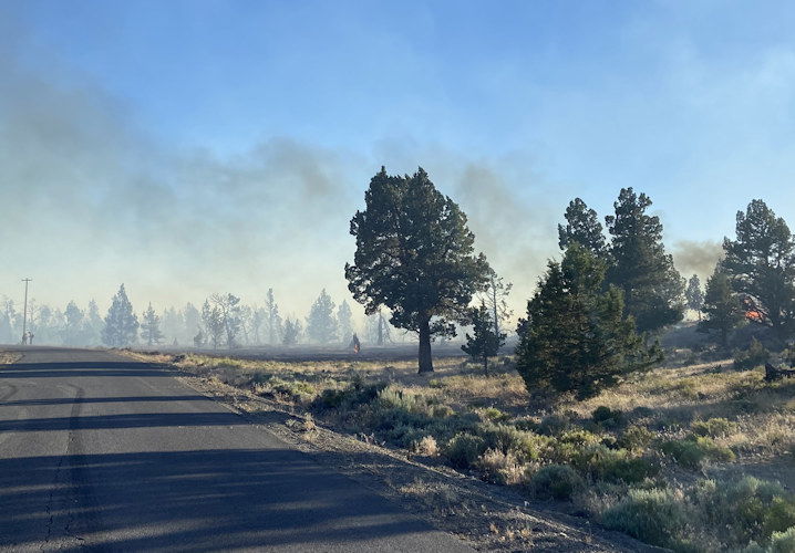
Forest Service Public Information Officer Kassidy Kern said, "This is not an area that we would see like maybe a normal fire, where we have a solid black. This has been a very spotty burn."
The cause of the fire is under investigation. Kern said, "Unfortunately, though, we know that it is human-caused, because we have not had lightning."
Knight added, "With the hot, dry conditions predicted, we're hoping to just keep the fire in the footprint. We haven't stopped it now, and then crews will continue to work working towards mop up and still containment throughout the day."
--
Meanwhile, the Prineville District Bureau of Land Management said Sunday it has implemented a temporary area closure of the BLM-managed lands around the McCaffery Fire area.
"This closure is in place for the safety of the public and to ensure that fire suppression activities to happen unimpeded," the agency said. "The order will be in place until rescinded."
Click on the link below to read the full closure in its entirety: https://www.blm.gov/sites/default/files/docs/2024-07/Prineville%20District%20Closure%20McCaffrey%20Fire%207.7.24_ASR_508_1_0.pdf
--
Saturday information:
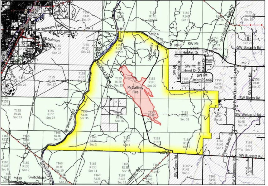
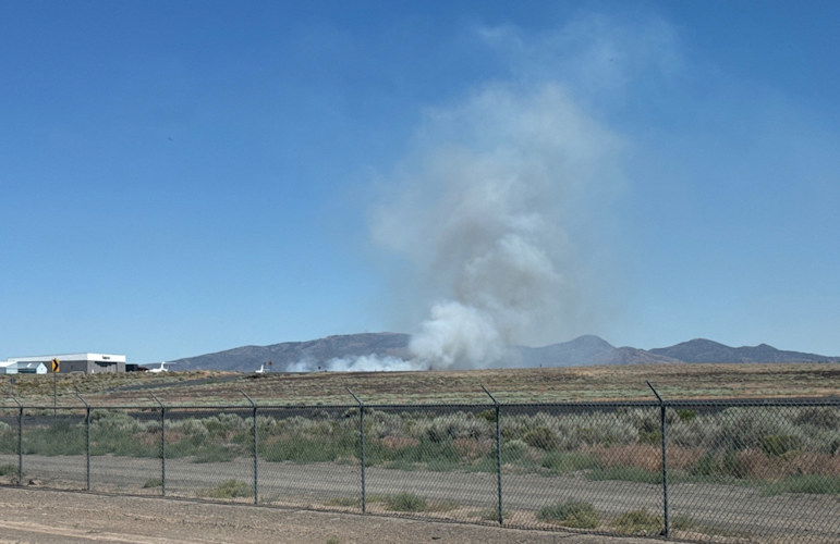
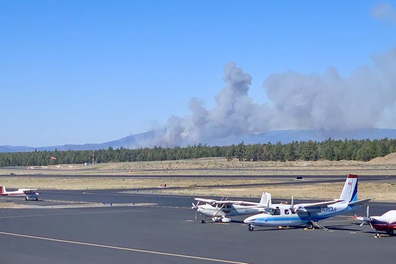
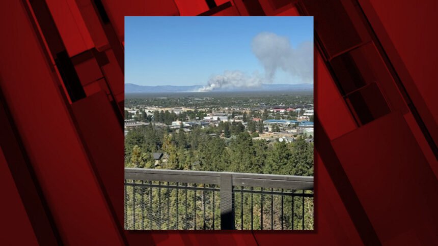
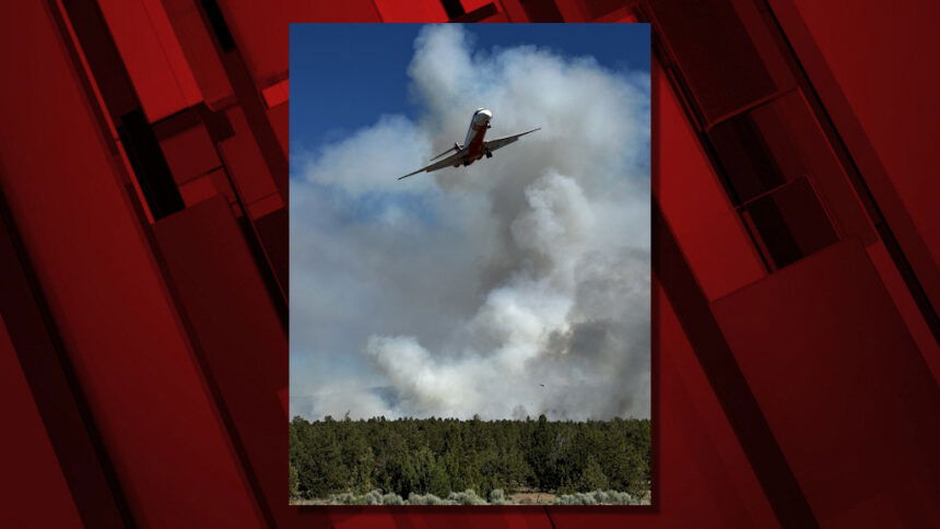
Incident 353, named the McCaffery Fire for McCaffery Road in the area the fire began, was reported shortly after 2 p.m. on Prineville BLM-managed land near the Deschutes/Crook county line, east of Redmond and west of Powell Butte.
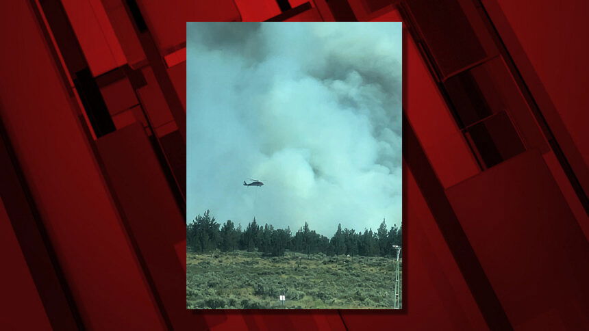
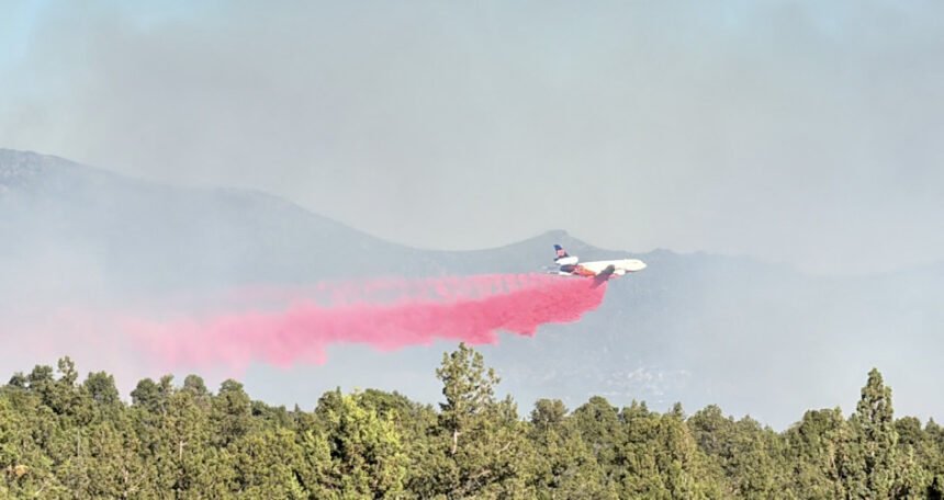
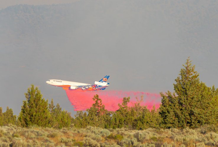
Several Forest Service and BLM crews quickly responded to assist Redmond firefighters during the afternoon, along with two single-engine air tankers (SEAT planes) to drop retardant, joined structural-protection task forces.
Three Large Air Tankers (LATs) helped firefighters on the ground, which also included private crews and a bulldozer, officials said early Saturday evening. They added that the fire at last report was still three miles from any structures.
Around 7:25 p.m., officials said in an update that "retardant drops have slowed the spread of the fire. Dozers and engine crews are working on flanking the fire at this time."
Redmond Airport's airfield closed for several hours on Saturday "due to adjacent wildfire fighting efforts" but reopened Saturday night.
They said the airfield had been closed "to dedicate air space to aerial firefighting efforts just east of the airfield." However, they said the terminal remained open and urged travelers to check with your air carrier directly for flight status updates and any cancellations.
Meanwhile, west of Bend, firefighters Saturday night stopped another new fire, Incident 356, off Forest Road 4615, two miles south of Skyliners Sno-Park. It was contained at a quarter-acre.
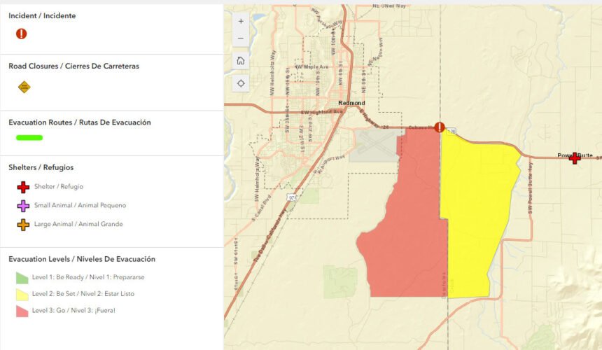
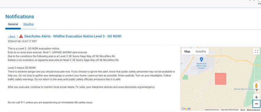
The Deschutes County Sheriff’s Office issued an initial Level 3 GO NOW evacuation notice shortly before 3 p.m. for SE Sunny Sage Way off McCaffery Road. Soon, an area of Crook County faced the same evacuations, but their Level 3 was reduced to Level 2 by 10 p.m.
--
Level 3: means “GO” evacuate now. Leave immediately! Danger to your area is current or imminent, and you should evacuate immediately. If you choose to ignore this advisement, you must understand that emergency services may not be available to assist you further. DO NOT delay leaving to gather any belongings or make efforts to protect your home. This will be the last notice you receive.
A Temporary Evacuation Point was established at the Powell Butte Church.
Large animals can be sheltered at the Crook County Fairgrounds.
Current maps including evacuation areas can be found at: https://deschutes.org/emergency
For fire information, you can visit the Central Oregon Fire information site at: www.centraloregonfire.org
Make sure you are registered for Deschutes Alerts to receive evacuation and emergency alert and warnings in your area by going to: www.deschutesalerts.org.
Crook County Sheriff John Gautney said Redmond Airport was giving priority traffic to fire aircraft. He said the fire was under the command of BLM, with a joint command with Prineville and Redmond Fire, the Oregon State Fire Marshal's Office and the Crook and Deschutes County sheriff's offices.
Pacific Power's outage map showed two "emergency de-energizations" in the area of the fire, affecting 176 customers. Crews were investigating a larger outage affecting 1,733 customers on Bend's south end.