Level 2 evacuation alert on Warm Springs Reservation due to Lionshead Fire
Other Fire updates: Holiday Farm destroyed 315 structures; 3 task forces called up to Brattain Fire threatening Paisley
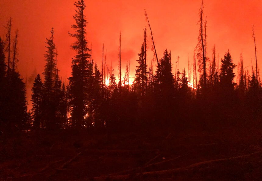
WARM SPRINGS, Ore. (KTVZ) -- A Level 2 "Be Ready" evacuation alert has been issued for the Sidwalter-Miller Flat area due to the still-growing Lionshead Fire, Police Chief Bill Elliott said Tuesday.
Here's his full statement:
Due to conditions presented by the wildfires affecting the Warm Springs Indian Reservation, a precautionary evacuation order Level 2 (which means for people to be prepared to move out at a moment’s notice) has been issued for the Sidwalter/Miller Flat area.
In order to provide protection to the property of those persons electing to go to the evacuation center established at the old school gym at the Warm Springs Agency area now, or if we move to a Evac 1 situation, the Warm Springs Tribal Police Department (WSTPD) is increasing patrols in the affected areas, in addition to increasing patrols on the major roadways due to heavy smoke.
The Oregon Army National Guard (ORARNG) will be assisting the WSTPD in the protection of these communities, this through the manning of traffic control points (TCP) in order to ensure that only residents and authorized personnel have access to these areas.
The support of the ORARNG is very much appreciated, and extremely important as it releases WSTPD units to continue to contact people within the community, make needed preparations should an evacuation be required, and respond to routine law enforcement calls for service.
Updates to our status are provided on the WSTPD Facebook page. However, for particulars concerning WSTPD patrol operations in regard to this event please contact WSTPD Lt Ron Gregory at 541-460-2271, or a statement and/or information regarding the ORARNG response to this event please contact Major Stephen Bomar, Director, Public Affairs, Oregon Military Department at 503-990-9508.
| Lionshead Fire Update – Tuesday, September 15, 2020 – 9:00 a.m. |
| Start Date: 8/16/2020 | Approx. Size: est. 168,097 ac. | Resources on the Fire: | Cooperating Agencies: |
| Cause: Lightning | Containment: 5% | 47 Crews | Marion Co. Sheriff |
| Incident Commander: | Total Personnel: 1182 | 49 Engines | Linn Co. Sheriff |
| Noel Livingston Pacific Northwest Team 3 | Approx. Distance: 14 miles west of Warm Springs | 9 Dozers 29 Water Tenders 11 Helicopters | Jefferson Co. Sheriff Deschutes Co. Sheriff |
Weather and Fire Behavior: Today winds will be light and dense smoke will not dissipate to the degree expected. Temperatures will be in the 70s with slightly higher humidity than yesterday. Firefighting efforts have been challenged both by lack of air support and unusually active fire behavior overnight. Active fire behavior is anticipated today, especially at higher elevations. There will also be a change in wind direction, from southwest winds yesterday to light east winds early today and north and northwest winds later in the afternoon. Some precipitation is possible Thursday.
Current Situation: Aviation assets were still unable to fly yesterday and flights will likely not be possible today because of poor visibility. The northeast portion of the fire on the Warm Springs Reservation continues to experience the most active fire growth. Crews worked there yesterday and through the night to build containment line and conduct strategic firing operations. Lionshead Fire Managers met yesterday with personnel from the Riverside Fire to coordinate their containment strategies and evaluate options for connecting road systems on the Mt. Hood National Forest to those on the Reservation. On the western edge of the fire, crews continued structure protection and damage assessments in Detroit Lake, Marion Forks and along the Highway 22 Corridor. Elsewhere, active fire behavior was seen just north of the Mt. Jefferson Wilderness boundary to the south and near Sisi Butte and Hawk Mountain, to the north and northwest. Crews constructed contingency fire line along the southern boundary yesterday.
Today’s Activities: Fire managers continue to coordinate closely with the Confederated Tribes of the Warm Springs on firefighting efforts. On the Warm Springs Reservation, crews plan to conduct strategic firing operations working from roads and dozer lines for containment. Crews will also continue yesterday’s work on structure protection and mop-up in the Olallie Lakes area. Structural crews will keep working in and around Stahlman and continue mop-up and structure protection around the impacted communities to the west. To the south of the fire, crews will scout for containment options west of the lava beds in the Mt. Jefferson Wilderness, taking advantage of features such as trails and old fire scars. Most of the eastern perimeter of the fire will be in patrol status today, meaning that mop-up there has been successful but crews will maintain watch to detect and suppress any spot fires.
Evacuations: The most current information on statewide evacuation information can be found at the Oregon Office of Emergency Management’s interactive database: https://www.oregon.gov/oem/emops/Pages/RAPTOR.aspx. Updates on evacuations on the Warm Springs Reservation can be found on the Warm Springs Police Facebook page.
Closures: For public and firefighter safety, roads and trails on the southwest portion of the Warm Springs Reservation near the fires remain closed to the public. Forest closures are in place for Deschutes, Mt. Hood and Willamette National Forests. Deschutes NF Alerts Willamette NF Alerts Mt. Hood NF Alerts
FOR ADDITIONAL FIRE INFORMATION: Fire Information: 971-277-5075
TripCheck: https://www.tripcheck.com/
Inciweb: https://inciweb.nwcg.gov/incident/7049/
Facebook: www.facebook.com/LionsheadFire
Email: 2020.lionshead@firenet.gov
Two Four Two Fire
September 15, 2020 9:00 a.m.
Oregon Department of Forestry IMT 2
Bill Hunt, Incident Commander
Email contact—twofourtwofire.information@gmail.com
Public Information Line: (541) 846-8174
InciWeb—https://inciweb.nwcg.gov/incident/7159/
Facebook—https://www.facebook.com/TwoFourTwoFire/
Size: 14,584 Acres
Containment: 15%
Start Date: Sept. 7, 2020
7:00 p.m.
Expected
Containment Date: Sept. 25, 2020
Location: Northwest of Chiloquin, Oregon
Cause: Unknown
Est. Cost: $3.3 million
Personnel: 500
Resources: 9 hand crews
36 Engines
17 Dozers
14 Water Tenders
Aircraft: 4 Helicopters
Evacuations: All evacuations expire
today at 9 a.m.
Level 3: (Go)
Hwy 62 from mile post
100 to mile post 94
Hwy 422 North from
U.S. 97 to Hwy 62
North of Collier State
Park Logging Museum
on Glendale Drive
Level 2: (Get Set) None
Level 1: (Get Ready)
Highway 62 from milepost 94 to Sun Mountain Road
Structures
Threatened: 1,278
Structures
Damaged: 70
Structures
Destroyed: 35
Closures: Road Closures are in
place at: Modoc Point
Road from Hwy 62 to
milepost 1; Hwy 62
from milepost 94 to
100; and Hwy 422
North from Hwy 97 to
Hwy 62
Fire Summary:
As of 9 a.m. today all evacuation are lifted. Access to highway 422
North will be open at noon. Highway 62 and highway 422 remain closed to
the public. Only residence of these areas will be allowed access. They must
show proof of residency to enter. The area will remain closed to nonresidents. Efforts are being made to reopen highway 62 and highway 422 north. Please check www.tripcheck.com for the latest updates.
Containing the fire requires diligent, labor intensive work. Working
within the fires interior, crews will search for hot spots. These hot spots
can be found in downed logs and tree stumps. Firefighters turn logs over
and dig out stumps then spray them with water until the material is cold to
the touch. Crews will work 25’ into the fire’s interior, building a crust
around the fire to secure the perimeter.
Safety remains our top priority. This includes trying to prevent
COVID-19 infections. Personnel are following the Center for Disease Control guidelines. This means limiting personal contact within fire camp and
the community. The fire camp is closed to the public and media.
State Fire Marshal Sends Resources to Paisley as Brattain Fire Threatens Community
Oregon State Fire Marshal - 09/15/20 10:27 AM
Gov. Kate Brown has declared a Conflagration to address changing conditions as the Brattain Fire threatens Paisley, in Lake County.
The Brattain Fire in Lake County is currently threatening lives, structures and property as it moves closer to Paisley. Forecasters yesterday had issued a Red Flag Warning for strong, gusty winds and low relative humidity.
The Office of State Marshal mobilized three task forces, who are at the incident today. Two task forces were sent from Oregon structural fire agencies and one task force was deployed from Idaho, following the state’s request for out-of-state resources through the state’s Emergency Management Assistance Compact (EMAC). Those resources joined existing local, state and federal resources currently at the incident.
Prior to last night’s declaration, Gov. Brown had made a statewide Conflagration Act declaration, and Oregon structural fire service resources from more than 100 agencies have been mobilized to 11 conflagrations statewide in a week.
For the past two days, weather systems have allowed some crews in Oregon’s fire service to begin pulling off of current deployments, while additional resources have arrived and are being mobilized from Utah, North Dakota, Minnesota, Washington and Idaho.
Calls for assistance from impacted fire districts continue to be managed through the Oregon Fire Mutual Aid System.
Additional updates for the incident may be accessed on the Oregon State Fire Marshal Facebook page: www.facebook.com/OregonStateFireMarshal/.
To learn more about wildfire evacuation readiness go to: www.oregon.gov/osp/programs/sfm/Pages/Wildland-Urban-Interface.aspx#evacuation.
BRATTAIN FIRE UPDATE
September 15, 2020 @ 9 AM
Virtual Community Meeting: Tonight @ 7:00 PM. Watch on Fremont-Winema National Forest Facebook page or listen live on KPAI 103.1 FM.
Current map: Bit.ly/Brattain
Yesterday:
Containment line has been established in the northeastern area of the fire along Hwy 31. Patrols continued work in the northeast and east to reinforce black line and protect property. Dozer work in the southern portion of the fire made significant progress and crews continued structural protection work in these areas. The most significant fire growth occurred on the northwest perimeter as the fire crossed the Chewaucan River in the evening. Additional fire resources were assigned to this area due to fire spread.
Today:
Warm and dry conditions coupled with strong, gusty winds will continue to be a challenge. A Red Flag Warning is in effect from 12 – 8 PM. Additional firefighting ground resources and aircraft are expected to arrive to bolster efforts. Forest Road 3510 and Clover Flat Road are being prepped as holding lines and mop up work will continue on the south and southwest perimeters. Establishing containment lines and structure protection are a priority in the northwest region of the fire.
Evacuations:
The Lake County Sheriff’s Office has issued the following evacuation notices:
Level 3 (Go) – Hwy 31 from Government Harvey Road/Forest Road 29 south to include all of Paisley, south on Highway 31 to Valley Falls/the junction with Hwy 395; All of Clover Flat Road from the intersection with Hwy 31 (Beachler’s Corner) south to Valley Falls.
Level 2 (Set) – From Government Harvey Road/Forest Road 29 north to Summer Lake Store.
Level 1 (Ready) – From Summer Lake Store north along Hwy 31 to the top of Picture Rock Pass; Abert Lake area southeast on US 395, south on Hwy 31 to Chandler State Park approximately 5 miles south of Valley Falls.
The Red Cross has an evacuation area at the Lake County Fairgrounds in Lakeview (1900 North 4th St.).
Forest Closure:
From Forest Road 29 southeast to Forest Road 3510 and from the 28 Road east, all National Forest System lands and facilities are closed per Forest Closure Order 06-02-03-20-03. Forest Road 3315 is closed; the 28 Road is open.
Summary:
The Brattain fire started on September 7th, 2020 and is currently burning on the Paisley Ranger District of the Fremont-Winema National Forest. The Eastern Area Incident Management Team is currently managing the fire. Firefighting crews continue to operate on a 24-hour schedule and are battling winds, extremely dry conditions and shortages of firefighting resources.
SIZE: 34,151 acres
CONTAINMENT: 15%
CAUSE: Human
PERSONNEL: 278
FIRE INFORMATION:541-947-6243
2020.brattain@firenet.gov
INCIWEB: inciweb.nwcg.gov search “Brattain Fire”
Facebook: www.facebook.com search:Fremont-Winema National Forest @R6FWNFSouth Central Oregon Fire Management Partnership @SOCFMPFIREINFO
LEVEL 3 EVACUATION
Hwy 31 from Forest Rd 29; Paisley; south & Clover Flat Road (both roads) to Valley Falls
LEVEL 2 EVACUATION
From Forest Rd 29 north to Summer Lake Store
LEVEL 1 EVACUATION
Hwy 31 from Summer Lake Store north to Picture Rock Pass; Abert Lake southeast on US 395; Hwy 31 south to Chandler State Park
The Red Cross has an evacuation area at the Lake County Fairgounds.
SAFETY:
Anticipate congestion on Hwy 31 due to fire traffic. Please use caution and avoid the area.
Beachie Creek Fire Update for Tuesday, September 15, 2020
Brian Gales, Incident Commander, NWIMT13
Les Hallman, Incident Commander, OSFM
Start date: Aug, 16, 2020
Location: Santiam Canyon near Detroit, OR, Marion County
Cause: Unknown
Fire size: 190,911 acres
Air Assets Assigned: 7
Total personnel: 545
Salem, Ore. – The increased acreage in fire size reported today is not due to fire spread over the past 24 hours but because an aerial assessment was completed. This allowed for a more accurate measure and improved mapping of the fire. Firefighters will resume work Tuesday to secure the perimeter of the Beachie Creek Fire. Crews and heavy equipment continue to connect and strengthen existing control line together on the west and northwest portions of the fire. Good progress was made in this area over the last couple days. Firefighters continue to work with landowners on the southeastern perimeter of the fire to build and secure control lines in that area. Firefighters will also continue mopping up and systematically assessing damage to structures inside the fire. Due to these efforts, firefighters have achieved 15% containment.
The Beachie Creek Fire and the Riverside Fire remain about one mile apart. Officials from nearby fires are coordinating strategies to minimize fire growth and stabilize incidents. Extremely dry vegetation and a lack of natural holding features in the Table Rock Wilderness and surrounding areas mean it is still possible the fires could burn together. Based on current weather, it is anticipated that a future merger would not result in dynamic fire behavior as seen last week.
Fire officials are working closely with the Marion County Sheriff’s Office, ODOT and the Oregon State Police to coordinate recovery efforts along the Santiam Canyon. Currently 16,776 structures are at Level 3 evacuations and another 18,528 homes in level 2 evacuations. It is imperative to protect first responders and communities in the path of the fire that everyone heeds fire and law enforcement road closures and evacuations. Anyone who enters the fire perimeter jeopardizes firefighting and rescue operations, puts lives at risk, and potentially increases the time it will take to return residents to their communities.
WEATHER: Inversions are likely to persist on the west side of the fire on Tuesday. High temperatures will be in the upper 60s to low 70s, with forecasted minimum relative humidity of 50 - 60 percent on the west side of the fire. Relative humidity is expected to be lower, 30-45 percent, on the east side of the fire and at elevations above 2,500 feet. The weather system forecasted to bring rain on Tuesday stalled and is too far west to add moisture to the fire. A low pressure system is forecasted for later this week with higher chances of rain.
SAFETY: Members of the public are encouraged to heed local evacuation orders issued by the county sheriff’s office and emergency notification systems. Know the Ready, Set, Go levels and make appropriate preparations. READY your belongings; SET your things at the door or prepack them in your car; GO and leave immediately.
SMOKE: Smoke will continue to be heavy across the area of the Beachie Creek Fire again today. This will lead to “unhealthy” and possibly “hazardous” conditions. Individuals with respiratory issues may find themselves affected by the intense smoke. Some mid-level cloud movement may allow for slight improvements to air quality mid-day, Tuesday. Smoke levels can change rapidly depending on weather. Check current conditions on DEQ's Air Quality Index or by downloading the free OregonAIR app on your smartphone.
CLOSURES: The entire Willamette National Forest is closed to all recreation including campgrounds, trails, days use areas, and boat ramps. Roads on the forest are closed to the public unless being used to evacuate. Bureau of Land Management (BLM) lands in the vicinity of the fire and State lands managed by Oregon Department of Forestry (ODF) including the Santiam State Forest are also closed to the public. Go to InciWeb (link below) for more information about closures in the area.
Holiday Farm Fire Information
September 15th, 2020
Oregon Department of Forestry IMT 3
Link Smith, Incident Commander
Oregon State Fire Marshal's Red Team
Ian Yocum, Incident Commander
Holiday Farm Fire Information: (541) 357-9729 (7am—10pm)
Lane County Non-Emergency Call Center: 541-682-3977 (7am-10pm)
Linn County Non-Emergency Call Center: 541-812-2260
https://inciweb.nwcg.gov/incident/7170/
email: holidayfarmfireinfo@gmail.com
Estimated Size: 166,573
Containment: 6%
Start Date/Time: 9/7/2020 8:20 p.m.
Expected
Containment Date: 10/29/2020
Location: Lane County
Cause: Unknown
Personnel: 767
Assigned Resources:
Hand Crews: 20
Engines: 50
Dozers: 27
Water Tenders: 13
Other Heavy
Equipment: 2
Assigned Aircraft: 7
Structure Task Forces: 5
Injuries: 0
Structures
Threatened: 23,456
Structures
Damaged: 14
Structures
Destroyed: 315 (7 failed)
Evacuations: Level 1 (READY), Level
2 (SET) and Level 3
(GO!) are in effect.
Springfield, Ore. –The Urban Search and Rescue Team has completed 431 structural evaluations in the fire area. The team started at the eastern edge of the fire in the community of Rainbow and have been working west down the Highway 126 corridor. The team expects to assess structures in the community of Blue River today. The team has assessed approximately 30 percent of the 1018 structures in the fire area. Structures include commercial buildings, residences and outbuildings.
Of the 431 structures evaluated by the team:
· 315 have been destroyed or failed (308 destroyed, 7 failed)
· 102 no damage reported
· 14 damaged
To ensure accurate information, Lane County partners are finalizing a process on how to release the damage assessments and share more detailed information with property owners. The Lane County Office of Emergency Management Call Center is available to assist homeowners and residents with damage assessment information. The Lane County Call Center can be reached at: 541-682-3977.
Structure protection, infrastructure rebuilding and wildland fire suppression activities continue throughout the fire area.
Structure protection continues to remain a high priority. Firefighters will work throughout the day to extinguish hot spots in and around structures along Highway 126. They are also mopping up along Highway 126.
Night crews conducted a burnout operation on the southwestern area of the fire on industrial timberlands above Deerhorn Road. The embers from the burnout started small spot fires that required crews to build additional fire control lines.
The Incident Meteorologist forecasted that today’s weather may lighten the smoke inversion which could increase fire behavior.
On a fire of this scale, fire crews are conducting small burnout operations to connect fire control lines and limit fire spread. In addition, the fire crews are using bull dozers and other heavy equipment, largely provided by private industrial landowners, to construct containment lines along the fire edge or open up existing road systems in preparation for additional burnout opportunities.
The Leaburg Dam has been repowered and refilled. It is now available as a strategic dip site for heavy helicopters with quick access to the most populated areas near the fire perimeter.
The Lane and Linn County Sheriff Offices continue to work with fire operations personnel to modify evacuation zones where appropriate. For the latest information on evacuation areas, please visit:
Lane County: www.lanecounty.org/mckenziefire
Linn County: www.linnsheriff.org/fire_live_updates_sept_2020/
Please continue to monitor cell phones, landlines, local media and official information sources for evacuation updates. Fire managers request that the public please avoid the area.
Roads are closed in the fire area and much of the Willamette National Forest (WNF) and Salem/Eugene BLM. Road hazards include falling trees and rocks and debris. For more information on closures on the WNF visit:
https://www.fs.usda.gov/alerts/willamette/alerts-notices/?aid=61574
For more information on closures on the BLM visit:
https://www.blm.gov/press-release/extreme-fire-activity-prompts-closure-bureau-land-management-lands-northwestern-oregon
Fire personnel are warmed by the community’s support but are unable to accept donations or use volunteers. The fire must use individuals with the appropriate qualifications. Those looking to volunteer or donate can connect with local organizations at:
