Pilot killed in crash of single-engine air tanker while working on new Eastern Oregon blaze near Falls Fire
(Update: Adding statement from Forest Service, sheriff)
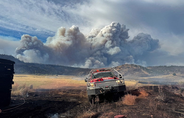
SENECA, Ore. (KTVZ) -- A BLM-contracted single-engine air tanker helping fight a new wildfire in Eastern Oregon crashed Thursday evening, killing the pilot on board, authorities said.
A Grant County Search and Rescue team located the aircraft Friday morning and confirmed the death, said Lisa Clark, a Bureau of Land Management information officer for the Falls Fire. The single-engine tanker, a small and nimble plane that looks like a crop duster, was located in steep, forested terrain on Friday morning after the search was suspended at nightfall the day before, Clark said.
Clark said the pilot was returning to Burns after dropping a load of retardant on the Parasol Fire, near the Falls Fire.
A statement from the Forest Service and Grant County Sheriff
JOHN DAY, PRAIRIE CITY and HINES, Ore., (July 26, 2024) — It's with deep sadness that we share the death of a member of the wildland firefighter community following the conclusion of search efforts for a BLM contracted single engine airtanker (SEAT). The SEAT and its pilot went missing last night while working in the vicinity of the Falls Fire. The fire was a new lightning start located near Seneca, Oregon, on the Malheur National Forest.
The Forest Service and Bureau of Land Management are working with local law enforcement and other agencies to investigate the circumstances and conditions related to the incident. A Serious Accident Investigation Team will be involved to learn from what occurred.
Additional information will be provided as it becomes available.
Please join us in keeping the family, friends, and colleagues of our fallen firefighter in your hearts.
The FAA confirmed the single-engine Air Tractor 802A crashed near Seneca around 11:30 p.m. local time, and only the pilot was on board.
Search efforts had begun immediately after the plane was reported missing Thursday evening near Seneca on the Malheur National Forest, about 25 miles south of John Day, and resumed Friday morning
The SEAT plane and pilot were called out on a new lightning-sparked fire start reported in the vicinity of the nearly 142,000-acre Falls Fire, which began more than two weeks ago and has over 1,500 firefighters on the lines, one of several "mega-fires" over 100,000 acres being battled across Oregon.
The aircraft was first reported missing close to 7 p.m., said Thomas Kyle-Milward, a spokesperson for the Northwest Incident Management Team 8, which was fighting fires in the area when the plane disappeared, The Oregonian/OregonLive reported.
The single engine air tanker can carry 800 gallons of water or retardant, and is operated by a single pilot, Kyle-Milward said. The plane was flown out of the Burns Municipal Airport, KGW reported.
Firefighters fighting the Falls fire, deputies from the Harney and Grant County sheriff’s offices and the National Guard all looked for the missing plane and pilot Thursday night, and National Guard aircraft used night-vision technology to search for the pilot overnight, Kyle-Milward said.
--
Falls Fire Update for July 26, 2024
Falls Fire Quick Facts:
Size: 141,927 Start Date: July 10, 2024 Location: 13 Miles NW of Burns, OR
Containment: 55% Total Personnel: 1,558 Cause: Human-caused, under investigation
Structures Triaged: Residences: 377; Commercial: 118 Outbuildings: 677
Resources Assigned: 38 hand crews, 79 engines, 24 bulldozers, 25 water tenders
Aerial resources available to the fire: two helicopters, and single-engine air tankers (SEATS)
New Fire Activity Quick Facts:
Whiskey Mountain: 2,565 acres; Cow Creek: 85 acres; Sand: 2,733 acres; Parasol: 353 acres; Poison: 39.6
Alaska Complex Incident Management Team 1 assumed command of Falls and Telephone Fires at 6:00 am Friday morning and remains in Unified Command with Oregon State Fire Marshal (OSFM).
Thursday afternoon, strong afternoon winds coupled with extremely dry fuels increased fire behavior on the Telephone Fire. Several new fire starts were located to the east of Falls Fire in the Parasol Butte area. Evacuation levels were issued and extended due to the new starts and Telephone Fire’s move across FSR28.
Crews assigned to the Falls Fire responded to new starts and the expanding Telephone Fire, along with aerial resources, to minimize the impact of fire growth. Structure protection crews quickly mobilized and also responded to the area. Telephone Fire has grown 3,000 acres and moved further to the southeast overnight and is approximately 4 miles north of Hwy 20.
Falls Fire: On Thursday, control lines continued to hold in areas where homes were previously threatened, including the Red Hill area and the Izee community. Prep has been completed by wildland and structure crews within the area directly adjacent to the Sand Fire, where the fire is steadily moving away from structures. This allowed OSFM assets to shift to the Telephone Fire, as fire activity moved to the northeast. Structural assets also continue to patrol the Highway 395 corridor, protecting properties to both the east and west. Structure crews responded alongside wildland resources to the Parasol Butte area to address structural protection related to multiple new fires in the area. This work continued overnight, with crews identifying structures and evaluating protection needs.
Crews on the southern and western perimeter continued to reinforce control line and mopped up additional hot spots. On the western side, firefighters conducted burn operations to tie the Whiskey Mountain Fire into the Falls Fire. Fire crews utilized direct attack and firing operations to protect resources to the west, including Izee. To the northwest, firefighters worked to tie together portions of control line using dozers and hand crews. On the northeast side, crews advanced fireline on the FSR31, moving west along Lonesome Creek with the assistance of heavy equipment. On the eastern edge, work progressed along FSR31, with fuel removal and mop up.
Today, crews will continue to mop up and hold areas on the south end of the Falls Fire. To the west, direct and indirect firing tactics will be used to tie Whiskey Mountain Fire into the Falls Fire and existing road lines.
Although Thursday was another active day, the threat to structures does still continue to trend downward. As part of the structure risk reduction, the number of surveyed and prepped structures has increased. This means that the location of structures is mapped, ensuring crews will know the best access routes, should they become threatened. The prep work that has been completed ranges from surface to full prep, depending on proximity to the fire. These extensive efforts help mitigate the risk to structures should the fire front move through the area.
New Starts: There were multiple new fires reported Thursday inside the Falls and Telephone Fire Temporary Flight Restriction (TFR) area. Resources assigned to the Falls Fire engaged in initial attack (IA). The largest of these starts is the Parasol Fire, located near Parasol Butte. It is estimated at around 353 acres. An additional start located near Poison Creek, was approximately 40 acres. Resources from multiple locations from the Falls Fire were assigned to both new starts. Firefighters will remain on the Parasol and Poison fires Friday and will work direct on the fire’s edge where possible. Firefighters assigned to the fires around the Falls Fire will respond to any new starts.
The Sand Fire, which is burning near Sand Mountain north of the Falls Fire, was discovered yesterday. Air resources assisted ground forces with suppression efforts and made steady progress throughout the day. OSFM Task Forces provided structural protection. Crews took advantage of cooler night temperatures to conduct strategic firing operations, in conjunction with heavy equipment, to create control lines. OSFM crews will work to complete protection work on structures in the vicinity.
Weather: Smoky conditions will continue through the morning. An inversion layer sits over the fire and is expected to lift by early afternoon. Temperatures will remain slightly lower today and will stay in the mid-80’s. Skies will generally be clear by afternoon. Like Thursday, northwesterly winds will become westerly and breezier in the afternoon before returning to northeasterly. Gusty winds can be expected over the fire again later today.
Evacuations: Evacuations remain in place in both Grant and Harney Counties and have expanded to include Level 3 evacuations due to the Telephone, Parasol and Poison Fires. For the most accurate evacuation information, please visit the Harney County Sheriff’s evacuation map here: https://tinyurl.com/3zst4sjy, or the Grant County Emergency Management Facebook page at: https://www.facebook.com/profile.php?id=100068819321423.
Closures: Due to active wildfires compounded by extremely unfavorable weather conditions, limited firefighting resources and County Resources, Malheur National Forest officials have temporarily closed lands within the Malheur National Forest.
Investigation: U.S. Forest Service fire investigators are seeking the public’s assistance with any tips or information pertinent to the start of the Falls Fire on the Malheur National Forest. Please submit any information that could assist fire investigation efforts to SM.FS.R6TipHotLine@usda.gov.
Facebook: https://www.facebook.com/p/Falls-Fire-2024-61562126623985/
Falls Fire InciWeb: https://inciweb.wildfire.gov/incident-information/ormaf-falls-fire
Telephone Fire InciWeb: https://inciweb.wildfire.gov/incident-information/ormaf-telephone-fire
Fire Information Line: 541-208-4370, staffed 8 a.m. to 8 p.m.
Email: 2024.Falls@firenet.gov
Harney County non-emergency evacuation questions: 541-589-5579
Air quality questions: 541-573-2271
Smoke Outlooks: https://outlooks.airfire.org/outlook
Related Links:
