Fire and smoke season linger into fall; large evacuation zone around Bingham Fire in Mt. Jefferson Wilderness

BEND, Ore. (KTVZ) -- A combination of weeks-old and newer fires continue to keep fire crews busy around the region as dry conditions linger.
Jaimie Olle, a public affairs specialist with the Deschutes National Forest, said Thursday that along with mopping up hot spots and patrolling the perimeter, as well as felling hazard trees and conducting burnouts to take away fuel that could send blazes over containment lines.
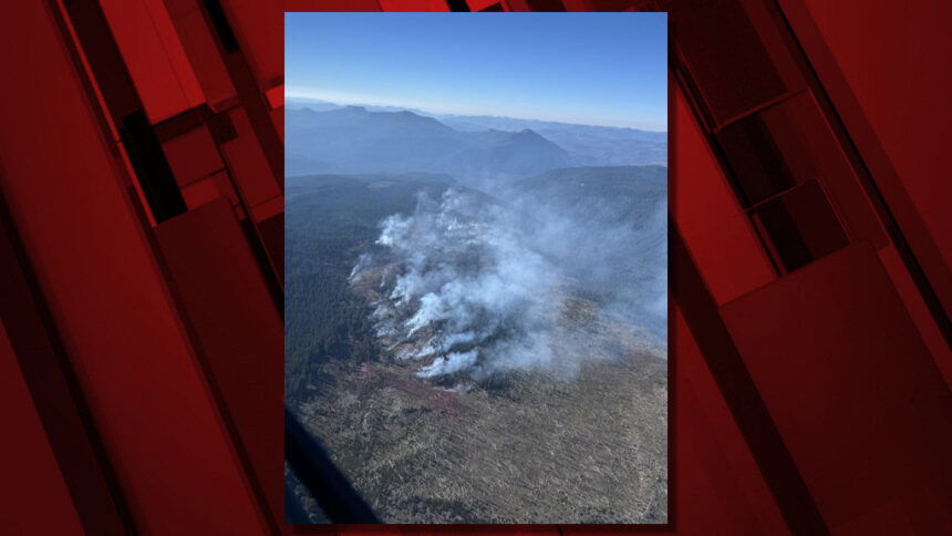
Another sign of the continued fire danger is Level 3 and 2 evacuation alerts the Linn County Sheriff's Office announced Wednesday around the nearly 200-acre Bingham Fire spotted Monday in the Mt. Jefferson Wilderness Area on the Willamette National Forest, about two miles east of Marion Forks.
Meanwhile, more fire activity and smoke are expected Friday due to warm, dry and windy conditions on the Little Lava Fire, part of the Bachelor Complex that has burned nearly 12,000 acres and is 55% contained, with 70 personnel still on it.
To the south, the Red Fire near Crescent Lake has burned 2,500 acres and has 73 personnel who have brought it to 11% containment. With low to moderate fire activity, the fire remains north of Forest Service Road 60. Crews continue to remove hazard trees, check pumps and hose lays and patrol control lines.
Here's Thursday's fire updates:
Bingham Fire Update for Thursday, October 3, 2024
Marcel Potvin, Incident Commander
Start date: Sept. 30, 2024
Location: Detroit Ranger District,
Willamette National Forest
Cause: Undetermined
Fire size: 195 acres
Full Suppression
Personnel: 126, including 4 Crews, 10 Engines, 1 Dozer
The Bingham Fire, located east of the Bingham Ridge Trailhead near Marion Forks, was reported on the evening of Sept. 30, 2024. The fire is burning partially within an older fire scar along the Bingham Ridge Trail that extends into the Mount Jefferson Wilderness area.
LEVEL 3: GO NOW! Evacuation Alerts have been issued by the Linn County Sheriff’s Office for a large area of the Mount Jefferson Wilderness. Additionally, LEVEL 2: GET SET Evacuation Alerts have been issued for the area around Marion Forks Campground, and Marion Forks Fish Hatchery. The Level 2 evacuation area also extends along Highway 22 to ½-mile west of Highway 22, from Pamelia Road (NFS Road 2246) south to Parrish Lake Road (NFS Road 2266). Please refer to the Linn County Wildfire Map for more information: https://tinyurl.com/LinnCoFireMap. Highway 22 remains open at this time.
A large evacuation area like this is necessary to give wildfire response teams enough space to safely travel to and fight the fire, as crews will be on road systems, trails, and air assets may be utilizing nearby water sources. The fire itself is much smaller than the evacuation area. The Willamette National Forest will be issuing an updated formal closure later today in the same footprint of the Level 3 Evacuation. The Pacific Crest Trail will remain open.
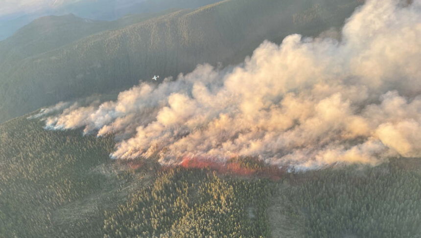
Firefighters are working as direct as possible to the fire’s edge. In the last two days, 18 smokejumpers, 11 rappelers, 3 hand crews, 1 hot shot crew, 10 engines, 4 professional falling teams and 1 dozer have responded to the fire and are preparing primary fire line and opening access routes to the fire area. Possible secondary and contingency fire lines are being discussed and scouted in the next few days. Shared air resources including helicopters and airtankers were able to complete multiple retardant and water drops on the fire to successfully slow the rate of spread. Additional resources have been ordered to support the full suppression actions.
WEATHER: Yesterday, cooler weather and higher humidity levels moderated fire behavior. Light easterly winds are forecasted for the fire area through mid-day Friday, with possible temperatures reaching the lower to mid-70s with lower relative humidity on Thursday. On Friday afternoon, rain is forecasted in the area, with the potential for up to 0.25 inches of precipitation. Smoke may be visible from Detroit, Idanha, and along Highway 22 today.
SAFETY: Members of the public are encouraged to heed local evacuation orders issued by the county sheriff’s office and emergency notification systems. Know the Ready, Set, Go levels and make appropriate preparations. READY your belongings; SET your things at the door or prepack them in your car; GO and leave immediately.
More fire information can be found on InciWeb: https://inciweb.wildfire.gov/incident.../orwif-bingham-fire
--
Rail Ridge Fire Update
October 03, 2024
Central Oregon Wildfire Information: centraloregonfire.org
Email: 2024.railridge@firenet.gov – Phone: 541-208-7111
Social Media, Evacuation and Closure Information: https://linktr.ee/RailRidgeFire
Acres: 167,718 – Containment: 89% – Detection: 09/02/24 – Cause: Lightning – Personnel: 795
Northwest Complex Incident Management Team 8, lead by Incident Commander Brian Ebert took command of the Rail Ridge Fire this morning at 6:00am. Thank You to Alaska Complex Incident Management Team #3 for your time, dedication and hard work on the Rail Ridge Fire.
Operational Update
Yesterday, calmer winds across the fire area led to subdued fire growth. The additional acreage burned was on the west/northwest area of the fire in the Black Canyon Wilderness in Honeymoon Creek. The tactical burning accomplished previously on the southern edge of the wilderness is still holding as a strong containment feature. Around the other contained areas of the fire, firefighters continued mop-up, patrol and suppression repair. The northern edge of the fire still has areas of fire perimeter which remain uncontained due to inaccessible terrain. Firefighters will continue to monitor these areas and work toward containment as they can safely engage.
Today, the fire team will continue to assess the fire activity in the wilderness and have management action points in place and are prepared to act on as the fire progresses. Firefighters continue construct contingency control lines and strengthen containment in the Black Canyon Wilderness, adding depth to lines that are already in place. Fire activity today is expected to be similar to yesterday. Even with the cooler night temperatures, the critically dry fuels will continue to burn and smoke will be visible across the fire footprint. The contained areas of the fire will continue to be patrolled, mopped up and suppression repairs are ongoing with resource advisors.
Weather
A cold start in the morning hours today will lead to similar temperatures as yesterday in the low 70’s. Winds will be light today and mostly terrain-driven across the fire area. Dry conditions will persist with stronger winds from the southwest on Friday.
Evacuations
Level 1 evacuations in Grant County were dropped yesterday and the level 2 evacuations remain. Wheeler County evacuation remain the same.
For Current Evacuation Levels all affected counties, please visit: https://linktr.ee/RailRidgeFire
Closures: The U.S. Forest Service and Bureau of Land Management have implemented closures for the Rail Ridge Fire. For more details and closure maps, visit https://linktr.ee/RailRidgeFire
