Lionshead Fire grows to nearly 10,000 acres; some wilderness trails closed
(Update: Some trails closed in Mt. Jefferson Wilderness )
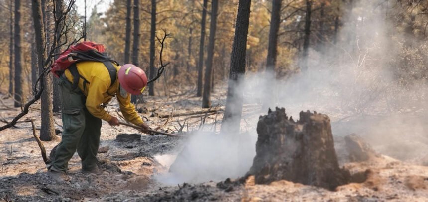
WARM SPRINGS, Ore. (KTVZ) -- The Lionshead Fire on the Warm Springs Indian Reservation grew to nearly 10,000 acres amid hot, windy weather on Thursday, with more challenging conditions expected into the Labor Day weekend and some closures of nearby trails.
The Deschutes National Forest issued this advisor Friday afternoon:
As of this evening, the Sisters Ranger District of the Deschutes National Forest temporarily will be closing some trails in the Mt. Jefferson Wilderness.
The trails are being closed because given fire behavior and weather conditions, the Lionshead Fire is expected to continue moving west and south and potentially enter the trail areas.
The closures include the following trails:
- The Jefferson Lake Trail (Trail 40001)
- The trail from Carl Lake north to Patsy Lake and Table Lake; however, the trail to Carl Lake remains open.
Visitors should follow these closure orders to avoid potential injury and create unnecessary risk to others.
Anyone hiking this weekend in Central Oregon should be prepared for high temperatures and carry adequate water and food.
Here's Friday morning's update on that fire and the nearly contained P-515 fire:
Quick Facts
Incident Summaries
P-515 / Lionshead
Approximate
Size in Acres: 4,609 ac. / 9,989 ac.
Fire
Containment: 95% / 31%
Incident
Commander Alan Lawson
Resources on
the fire:
Crews: 17
Helicopters: 7
Engines: 27
Water Tenders: 17
Dozers: 2
Total
Personnel: 572
Jurisdiction:
Confederated Tribes
of Warm Springs
Oregon Smoke Blog
http://oregonsmoke.blogspot.com/
Facebook
https://www.facebook.com/KWSOnews
https://www.facebook.com/northwestteam10/
Inciweb
https://inciweb.nwcg.gov/incident/7050/
https://inciweb.nwcg.gov/incident/7049/
Update-Friday, September 4, 2020
Incident Commander: Alan Lawson, Northwest Team 10
E-mail – 2020.p515@firenet.gov
Fire Information: 971-277-5075
Warm Springs, Oregon - This update is for the P-515 Fire and Lionshead Fire burning on the Warm Springs Reservation. Both fires are being managed for full suppression.
Current Status: The P-515 fire remains in mop up and patrol status. Resources no longer needed on P-515 are assisting crews on the Lionshead fire. As resources reach their 14-day limit, they are being demobilized as appropriate to meet operational needs.
The Lionshead Fire is now 9,989 acres and 31% contained. The fire has progressed farther to the west and southwest, moving up the Whitewater River and Milk Creek drainages. The fire has pushed the southwest flank, crossing an established dozer line. Air resources have continued to work on slowing spread, with multiple heavy air tankers dropping retardant on the southern flank throughout the afternoon. Helicopter resources, including the Air National Guard supported ground resources throughout the afternoon, yesterday.
Today’s Operations: Air resources will continue to support ground crews on the southwestern flank to slow spread, as crews work to determine possible fire line locations in the southwest flank. On the NW flank, crews will continue to look for opportunities to extend line to the west. Fire crews face continued challenges due to the difficult terrain, high temperatures and dry conditions.
Weather and Fire Behavior: Transport winds will push smoke to the northeast with winds to 13 mph, and lower elevation gusts to 20 mph. Temperatures will be 15 to 20 degrees above average with slightly cooler temperatures at higher elevations. Abundant dry fuels, difficult terrain and persistent burning conditions with very active fire behavior into the overnight hours is expected.
Closures: Trout Lake Road at pavement end; Road B140 at Potter’s Pond; Road B210 and Road P-500. All trails south of Trout Lake, west of M-120 Metolius Bench, east of Mt. Jefferson, and north of J-195 will be closed to the public. Tenino Road (P-200) is closed to the public, with only fire personnel and residents permitted.
Evacuations: There are currently no evacuation orders associated with the P-515 or Lionshead Fires.
COVID-19: Our highest priority is the safety of the public and all wildland fire personnel. To keep firefighters and communities healthy and safe during the P-515 and Lionshead Fires, all fire personnel are expected to follow recommendations from the Centers for Disease Control and Prevention (CDC). This includes limiting public access to the Incident Command Post (ICP) at the Warm Springs Fairgrounds. While COVID-19 circumstances are rapidly evolving, and federal agency guidance continues to adapt with the situation, NW Team 10 is prepared for wildland fire activity during this time.
Prevention Message: Let’s unite, not ignite! Prevent wildfires.
Beachie Creek Fire Update
Friday, September 4, 2020
| Size: 200 acres | Location: Opal Creek Wilderness, Willamette National Forest (6 miles north of Detroit) |
| Containment: 0 percent | Suppression Strategy: full suppression |
| Date Detected: August 16, 2020, 11:18 a.m. | Cause: unknown |
| Resources: 1 crew, 1 road grader, 1 water tender, 1 backhoe, 45 total personnel, 1 Type 2 helicopter. 1 Type 1 helicopter and 1 Rappel ship |
Current Situation:
Thursday the fire grew to over 200 acres. The higher relative humidity levels yesterday likely slowed the movement of the fire. It continues backing down towards Beachie Creek and Opal Creek. The main progression is to the Southeast towards French Creek Ridge. Expect similar movement for Friday.
Smoke, especially in the early afternoon, will continue to affect the areas of Detroit, Jawbone Flats and communities in the Little North Fork an Elkhorn Valley. Smoke from the Lionshead and P-515 fire on the Warm Springs Reservation may be affecting the area.
Aviation will continue to be used to reduce the fire activity and limit the fire growth. While a Type 2 Initial Attack crew continues to brush roads, to reduce fuel, and prepare the roads for contingency lines.
A Type 2 Incident Command team took control of the fire at 6:00 a.m. on Friday under the command of Brian Gales. Additional resources are arriving over the weekend.
Weather and Fire Behavior:
Increasing East winds expected early next week. High pressure remains anchored over the region with warm temperatures and dry conditions expected through the weekend. Expect favorable relative humidity recovery both Thursday and Friday night with daytime minimum relative humidity values staying above critical thresholds.
Closures: Willamette National Forest roads, trails, and lands around the fire area are closed. View the official order (Order 06-18-04-20-13) or go to InciWeb (link below) for a list and map of the closed, roads, trails, and recreation sites.
Temporary Flight Restriction (TFR): Airspace over the Beachie Creek Fire area is restricted. Drones are not allowed within the TFR. Remember: If you fly, we can’t.
Fire Restrictions: Campfires are restricted to developed campsites with Forest Service provided fire rings. For a complete list of what is and is not allowed, go to the forest’s fire webpage: fs.usda.gov/main/willamette/fire. Never leave a campfire unattended. Drown it with water, stir it thoroughly, and feel it with your hand to ensure that it is out cold. The Willamette has determined for everyone’s safety that campfires will only be allowed in designated campgrounds. (Order 06-18-00-20-16).
Beachie Creek Fire Information:
InciWeb: https://inciweb.nwcg.gov/incident/7001/ Facebook: @WillametteNF@WillametteNF
Twitter: @WillametteNF
E-mail: 2020.beachiecreek@firenet.gov
Phone: 541-583-0526, 8 a.m. to 8 p.m. ###
