Wildfires update: Ochoco Natl. Forest douses escaped campfire, 2 ‘reckless starts’
(Update: Ochoco National Forest fires; more of Hwy. 126 reopened)
New Grant County fire stopped; winds may test fire lines
PRINEVILLE, Ore. (KTVZ) -- As the state battles several major wildfires and generally dry conditions continue, the Ochoco National Forest said late Tuesday that crews had responded to three new fires in the past 24 hours -- an escaped campfire and two "reckless human-caused starts."
In a Facebook post, the forest reminded visitors that campfires are not allowed on the forest or Crooked River National Grassland, part of statewide restrictions amid high fire danger.
"If you need to cook food, plan ahead and bring a portable cooking stove," officials said.
Anyone who spots an illegal fire is asked to contact Forest Service Law Enforcement officers or the non-emergency sheriff's office line.
ODOT update: Tuesday night
OR 126 McKenzie Highway update: The road is now closed between milepost 28 and milepost 40, from Vida to Blue River. Traffic approaching the closure points may be limited to essential services at any time due to hazards. Tree removal and utility work are ongoing. Enter newly opened sections with extreme caution. Downed trees and brush piles are near the fog line. There are numerous work zones outside of the closure area. Traffic outside of the closure area should expect very long delays.
---
While some 7,500 firefighters continue to battle several major wildfires around Oregon, new ones continue to emerge, including a lightning-sparked blaze Monday in Grant County that raced across nearly 700 acres before being stopped.
Here's the report on the Ritter Fire from the Oregon Department of Forestry's Central Oregon District:
Late Monday afternoon, an engine patrolling for wildfires from the Oregon Department of Forestry’s Long Creek Guard Station in the John Day Unit reported a fire burning about seven miles north of Long Creek in Grant County.
The fire was initially reported as an acre, but quickly spread in grass and brush, and by dark, forward progress was stopped at 676 acres.
Ten aircraft were used to slow the spread of the fire to allow firefighters to engage the fire on the ground and build a fireline. Overnight, dozers were used to strengthen the fireline, and as of Tuesday morning, the fire was 20% contained.
“This was a great catch!” praised Allison Blair, John Day Unit Forester. “The quick assistance from aircraft was critical to stopping this fire.”
Resources from the Long Creek Fire Department were requested to provide structure protection as fire threatened structures in the area. No structures were damaged during initial attack.
In addition to ODF assets, landowner resources, and crews and fire engines from the Malheur National Forest assisted in suppression efforts.
On Tuesday, nine engines, two crews, a tender and a bulldozer continued working to secure the perimeter, mop up hot spots near the fire’s edge and look for areas of heavy fuel which could flare up.
Within the interior of the fire there are some large hay bales which will continue to burn and smolder as they are consumed. The area around these hay bales is burned and they do not pose a risk of fire spread, but will continue to smoke.
Firefighters found the cause of the fire to be a lightning strike from the passing thunderstorms Friday night. The fire appears to have held over, burning undetected within a tree for the past several days, and spreading rapidly after it moved to the lighter, flashy fuels.
A regulated-use closure remains in effect for activities such as mowing of dry grass, chainsaw use, and open fire restrictions. The closure also requires those traveling on forest roads to carry a shovel and a fire extinguisher (or one gallon of water).
Visit www.odfcentraloregon.com for full details. The public is asked to be aware of any actions which could cause a wildfire.
ODF’s Central Oregon District continues to serve landowners and the public as an essential service for Oregonians. Please call or email to talk with our staff or schedule an appointment. For additional information on ODF’s Central Oregon District, including contact information and unit offices, please visit www.ODFcentraloregon.com.
The Oregon Office of Emergency Management, in its daily update, noted nearly 4,000 Oregonians have registered with FEMA for Individual Assistance, with about $4.7 million already approved. Leare more at DisasterAssistance.gov.
Tuesday's ODF fire report:
SALEM, Ore. - The Oregon Department of Forestry is closely monitoring 10 major fires in Oregon, down from 17 originally (see table below for details). Fires are removed from the list when they are 100% lined and fire managers are confident in their progress toward containment.
There have been more than 7,500 personnel assigned to these fires, not including many of the government employees, landowners, forestland operators, and members of the community who are contributing every day. There have been resources from 39 states and multiple Canadian provinces in this fight alongside Oregonians.
About 1 million acres have burned in Oregon since the start of this year, which is nearly double the 10-year average of approximately 557,811.
| Fire name | Acres burned (est.) | Containment | Location |
| Lionshead | 198,647 | 13% | 20 miles W of Warm Springs |
| Beachie Creek | 192,764 | 38% | 15 miles N of Detroit |
| Holiday Farm | 170,637 | 17% | 3 miles W of McKenzie Bridge |
| Riverside | 137,880 | 25% | 2 miles SE of Estacada |
| Archie Creek | 131,598 | 41% | 20 miles E of Glide |
| Brattain | 50,447 | 52% | 8 miles S of Paisley |
| Slater | 42,214 in Oregon | 18% | SE of Cave Junction (also in No. California) |
| S. Obenchain | 32,671 | 65% | 5 miles E of Eagle Point |
| Two Four Two | 14,473 | 77% | W/NW of Chiloquin |
| Thielsen | 9,689 | 22% | E of Diamond Lake |
More information
- ODF wildfire blog and Significant Fire Potential Map
- Northwest Coordination Center – Regional Update and National Situation Report
- Inciweb (information on individual incidents
Lionshead Fire Update
Tuesday, September 22, 2020 – 10 a.m.
Firefighters Prepare for Increasing Winds
Special Notice: There will be a virtual community fire information meeting on Wednesday, September 23, 2020 at 6:00 p.m., PDT. An update on the status of the fire may be provided by fire managers and cooperating agencies. The meeting can be viewed via Zoom at this link: https://usfs.zoomgov.com/j/1606494587.
Current Situation:
Increasing winds are posing a hazard along road corridors and the fireline due to the possibility of falling snags and fire damaged trees. Hazardous tree removal work along roads and constructed fireline will also be affected by increasing winds.
Even though a rain event is approaching, active burning may occur today due to warmer, drier conditions and stronger winds. Smoke may increase as interior green islands burn, but little expansion of the fire’s perimeter is expected. The wind may reveal areas that need more attention along the fire edge.
Structure protection personnel continue assessments of structures impacted by the fire. Structure protection work is ongoing in Sidwalter, Idanha, New Idanha, and Detroit.
Air quality has improved due to the rain and cooler temperatures over the past few days. Good to excellent humidity recovery at night may also be helpful. The shorter days may have an impact on fire spread as the burning period decreases. Predicted rain (as much as 1 inch in some areas) should have a positive impact on firefighting efforts.
Firefighting Efforts by Division: (Refer to the map for division breakdown.)
Additional crews may be working in division A on the north of the fire today. Previous burnouts look good and secure. The area around Badger Butte continues to pose challenges due to terrain and snags but progress is being made. Green islands inside the fire perimeter in Division A may produce smoke as they burn. Crews continue to mop up and patrol for hotspots.
In Division E, patrol and chipping operations continue.
Divisions G, I, K, and N have been quiet for several days and continue to be secure. Firefighters are monitoring and patrolling this area. Most of the road system has been prepped and is now being reinforced in these divisions.
On the southeast perimeter, working west from the Division N/R break (north of Jefferson Lake), the fireline has been secured west to the lava rock area.
Much of the perimeter in Division S has checked along the road system. There hasn’t been any significant fire movement or spread in this division for several days.
The fire in Division T has mostly been checked on existing roads. Canadian crews assisting in this division have been a great asset. Crew work is primarily patrol and cold trail along those roads. Cold trailing is a method of controlling a partly dead fire edge by carefully inspecting and feeling with the hands for heat to detect any fire, digging out every live spot, and trenching any live fire edge. In particular, firefighters are looking for any spread across roadways. Spot fires in this division have been contained.
Division W has no crews assigned due to higher priorities elsewhere, but supervisors continue to assess needs for future work.
In Divisions Y and Z, the focus is patrol for spot fires and mop up. In Division Z, an indirect line is being prepped and improved. Heavy equipment work continues along the 46 Road as it is prepped for possible use in indirect attack. The 46 Road remains closed due to the large amount of heavy equipment required for this effort. This road may remain closed until snag hazards are cleared and the road is deemed safe for public travel.
Contingency groups are improving indirect fireline. The south contingency group is working along County Road 12 to County Road 20, creating fuel breaks along the road. The north contingency group is working in close coordination with Riverside Fire managers to identify opportunities to connect existing roads that both fires could use in the event these indirect lines are needed.
Air operations will support efforts in Divisions A and Z today.
Weather & Fuel Conditions: Today may be mostly cloudy with winds on the increase as a low-pressure system approaches. Winds from the southwest will increase with sustained winds around 8-12 mph and gusts to 20 mph along ridgetops and drainages that run southwest-northeast. Wet and windy conditions are predicted Wednesday through Friday. Rain may develop over the fire late Wednesday afternoon and increase through the night. Rainfall accumulations of 1.25-1.5 inches are expected west of the Cascade crest and 0.5-0.6 inches for the east side of the fire.
Closures and Evacuations: Evacuation Notices remain in place for the Lionshead Fire. Level 3 “Go!” evacuation notices are still in place for the communities of Detroit, Idanha, and Breitenbush. There are no longer any evacuation notices for the Sidwalter/Miller flats area.
Roads and trails near the fire remain closed for public safety. The 12 Road may remain closed to the public for the near future. This includes roads and trails on the Confederated Tribes of Warm Spring lands adjacent to the fire and a 40-mile section of the Pacific Crest Trail between Santiam Pass and Olallie Lake. Forest closures are in place for Deschutes, Mt. Hood and Willamette National Forests: Deschutes NF Alerts Willamette NF Alerts Mt. Hood NF Alerts.
Temporary Flight Restrictions: A Temporary Flight Restriction is in place over the Lionshead Fire and surrounding fires. Wildfires are a No Drone Zone. If you fly, we can’t. Whenever a drone is spotted near the fire all aircraft are grounded until we can be sure the drone is clear of the area. For more information, visit knowbeforeyoufly.org.
Reminder: Schools re-open TODAY, September 22, 2020.
| Lionshead Fire Statistics: Size: 199,016 acres Containment: 13% Total Personnel: 1,029 Location: 14 miles west of Warm Springs Reported: 8/16/20, approximately 8:44 p.m. Cause: Lightning | For More Information: Information Office: 971-277-5075, 8 a.m. to 8 p.m. Media Inquiries: 541-904-0542 Email: 2020.lionshead@firenet.gov InciWeb: https://inciweb.nwcg.gov/incident/7049/ You Tube: http://www.youtube.com/channel/UCHSR6_yJRQkHyGjvvqX99gw Facebook: facebook.com/LionsheadFire |
BEACHIE CREEK FIRE UPDATE – September 22, 2020
Acres: 192,775 acres Percent Containment: 38%
Start Date: August 16, 2020 Cause: Under Investigation
Origin Location: Opal Creek Wilderness: Fuels: Timber and logging slash
two miles south of Jawbone Flats, Resources: 788
six miles north of Detroit, Oregon. Flights: Temporary Flight Restriction
Virtual Community Meeting Beachie Creek Fire, Tuesday, September 22, 6 pm,
Beachie Creek Facebook Live: https://www.facebook.com/BeachieCreekFire2020
Firefighters securing areas around private property Tuesday
Big Push - Prepping for Wednesday winds and rain
Salem, Ore. – Firefighters take advance of favorable weather conditions Tuesday by securing lands adjacent to private property. They are creating defensible space by clearing ground that prevents the spread of wildfire. Today will be the best day to detect and destroy isolated hotspots from within the fire perimeter. Crews are right on the fire’s edge securing and connecting control lines. Heavy Equipment is also being used, especially on the western edge to build stronger control line.
The focus on Tuesday is to make a strong push to prepare all areas of the fire in advance of Wednesday’s predicted wind and rain. The winds will start Wednesday morning at about 12 miles per hour, and by noon gust as high as 40 miles per hour. Rain will follow. The winds will be strong enough to blow weakened or burned trees over. Additional rain could cause rockslides, mudslides, and other falling hazards. The Marion County Sherriff deputies and fire personnel are advising residents about the impact of weather after fire.
Although good progress has been achieved around the Beachie Creek fire perimeter, internal hot spots remain. On the western side of the fire, the land is flat and more accessible to firefighters who are protecting those communities. Crews work to keep the fire east of highways 213 and 214. There will be many days of work ahead to reach a sloid containment line from the north, down the western edge and then moving through the southern State Route 22 corridor. The terrain on the eastern side of the fire is rugged with deep canyons and high ridges. That side of the fire is in and near Wilderness and being monitored by air.
Currently 1,118 structures are at Level 3 evacuations and another 4,574 are in level 2 evacuations. As more residents are allowed back into the area, it is imperative that everyone heeds road closures and safety messages. Anyone who enters the fire perimeter jeopardizes firefighting operations and puts lives at risk.
The Willamette National Forest, Bureau of Land Management, and State lands around the fire remain closed to the public. Go to InciWeb.gov for more information about closures in the area.
| Public Contact Information: https://www.facebook.com/BeachieCreekFire2020 Email: 2020.beachiecreek@firenet.gov Phone: 541-583-0526, 8 a.m. to 8 p.m. | Inciweb https://inciweb.nwcg.gov/incident/7001/ Smoke and Air Quality http://oregonsmoke.blogspot.com/p/air-quality-now.html https://wildlandfiresmoke.net/outlooks |
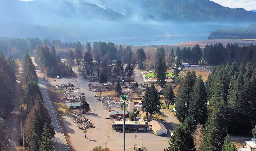
Holiday Farm Fire
Tuesday, Sept. 22 Update
Springfield, Ore. – Bit by bit, containment on the Holiday Farm Fire continues to grow. Between infra-red flight data and on-the-ground truthing by field observation specialists, the fire now stands at 173,094 acres and 22 percent contained.
The southwest corner of the fire, just below Leaburg, is moving into patrol status. Due to the enormity of the fire, crews have begun to remove excess hose from this area and will transfer it to other areas of the fire. Because there are several pockets of unburned vegetation within the perimeter of the fire, residents can expect to see smoke and some torching of trees within the footprint of the fire. Please refrain from calling 911 on these smokes. Up to seven helicopters will be available to support firefighters on the ground, cooling edges and allowing crews to construct direct line along the perimeter.
Firefighters continue to strengthen containment lines in several other areas in advance of the weather system moving in Wednesday that will bring elevated winds out of the southwest. Rain is also expected later in the day on Wednesday.
Hazards along Highway 126 still exist. The McKenzie Highway remains closed between Leaburg Dam Road (milepost 23.9) and McKenzie River Drive (mp 46.3). For more information regarding road closures and delays, visit https://www.oregon.gov/odot/Pages/Wildfire.aspx or www.tripcheck.com.
Level 1 and 2 evacuation notifications remain in effect for several communities within and bordering the fire area. For more information on current evacuation levels, visit www.lanecounty.org/mckenziefire for Lane County and www.linnsheriff.org/fire_live_updates_sept_2020/ for Linn County. Please continue to monitor cell phones, landlines, local media and official information sources for evacuation updates. Fire managers request that the public please avoid the area.
BRATTAIN FIRE UPDATE
September 22, 2020 @ 9 AM
SIZE: 50,510 acres
CONTAINMENT: 55%
CAUSE: Human
PERSONNEL: 481
FIRE INFORMATION:
541-947-6243
INCIWEB:
inciweb.nwcg.gov
search “Brattain Fire”
Facebook:
facebook.com, search:
Fremont-Winema National Forest @R6FWNF
South Central Oregon Fire Management Partnership @SCOFMPFIREINFO
LEVEL 1 EVACUATION
Highway 21 from Red House Lane (north of Paisley) north to Forest Road 29, also known as Government Harvey.
The Red Cross has closed the evacuation area at the Lake County Fairgrounds.
SAFETY:
Hwy 31 is open but anticipate heavy fire traffic. Avoid the area if possible. Temporary Flight Restrictions are in effect. Avoid drone use and report drones to law enforcement.
Yesterday:
Fire activity decreased even more yesterday, with containment lines holding well and only interior portions of the fire showing any activity. Mop up activities and line patrols remained a priority. The northwest corner, which is littered with heavy down and dead fuel loading, is still smoldering but is not a threat. The eastern side of the fire remained quiet, but patrols are keeping a close eye on the perimeter regardless. The noticeable increase in hazy conditions was caused by smoke from the California wildfires.
Today:
Active perimeter patrolling will remain a priority, and work will continue on contingency lines, hot spots and mopping up. Rehabilitation and repair planning will continue. Two graders will be maintaining roads that access the fire to allow safe access for fire equipment. Collaboration has begun between private landowners and agency land managers regarding future rehabilitation activities on private lands. Gusty winds out of the southwest are expected through Wednesday. However, higher dewpoints, cooler temps, and some clouds will help moderate any fire behavior. There may be visible fire activity in some of the interior unburned pockets of fuel. These areas are situated well inside the fire perimeter and should not pose any threat to any of the containment lines. The transition to a more localized incident management team will begin Wednesday evening.
Evacuations:
Area residents should sign up for Lake County Alerts, a mass notification system that provides residents with both emergency and non-emergency notifications.
Sign up at https://public.alertsense.com/SignUp/?regionid=1535.
Only one evacuation remains.
The Lake County Sheriff’s Office has updated the following evacuation notice:
Level 1 (Ready) –Highway 21 from Red House Lane (north of Paisley) north to Forest Road 29, also known as Government Harvey.
Forest Closure:
From Forest Road 29 southeast to Forest Road 3510 and the 28 Road east, all National Forest System lands and facilities are closed per Forest Closure Order 06-02-03-20-03. Forest Road 3315 is closed; the 28 Road is open.
Summary:
The Brattain fire started on September 7, 2020 and is currently burning on the Paisley Ranger District of the Fremont-Winema National Forest. The Eastern Area Type 2 Incident Management Team is currently managing the fire but will soon transition to a smaller, more localized team. Firefighting crews continue to operate on a 24-hour schedule and are battling winds, extremely dry conditions and shortages of firefighting resources.
Two Four Two Fire
September 21, 2020 11:00 a.m.
FINAL UPDATE
Email contact—twofourtwofire.information@gmail.com
Public Information Line: (541) 846-8174
Inciweb—https://inciweb.nwcg.gov/incident/7159/
Facebook—https://www.facebook.com/TwoFourTwoFire/
Size: 14,473 Acres
Containment: 89%
Start Date: Sept. 7, 2020
7:00 p.m.
Expected
Containment Date: Sept. 25, 2020
Location: Northwest of Chiloquin, Oregon
Cause: Unknown
Est. Cost: $6.8 million
Personnel: 380
Resources: 8 hand crews
21 Engines
3 Dozers
11 Water Tenders
Aircraft: 1 Helicopter
Evacuations: None
Structures
Threatened: 0
Structures
Damaged: 33
Structures
Destroyed: 48
Closures: None
Fire Summary:
Last night an infrared flight flew over the fire to identify any areas of heat
near the perimeter of the fire. Any identified hot spots will be taken care of today before crews are demobilized at the end of their shifts.
There are videos by Operation Section Chief, John Pellissier, flying over
the fire on the Two Four Two Fire Facebook page. These videos highlight the work that has been done on the fire. No account is required to view the videos.
Today is the last day Oregon Department of Forestry Incident Management Team #2 will be in command of the fire. Transition to a local Type 4 team
will happen at 8:00am tomorrow morning.
The objectives for the Type 4 team remain the same. The crews will continue mop up where it warrants and continue suppression repair. The local team will staff the fire with multiple engines, water tenders and dozers through the week. ODF and USFS are expecting the fire to be 100% contained by the end of shift on Friday.
This will be the final fire update from Team 2. The incident management
team would like to thank the cooperators and public for working together on this fire. Without local resources and support from the community our team would not have been as successful.
Firefighter and public safety is the top priority during this incident, including COVID mitigation. Personnel will be following Center for Disease Control guidelines to limit personal interactions both within camp and with the local community. The incident command post and fire camp are closed to the public and media.
