Wilderness location, rugged terrain prompt shift to indirect battle against 318-acre Petes Lake Fire
(Update: Adding Thursday update, reduced acreage)
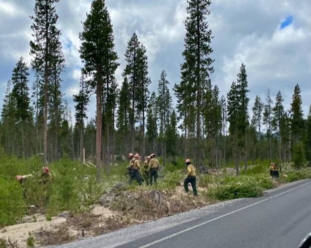
Shaded fuel break being created along Cascade Lakes Highway
SISTERS, Ore. (KTVZ) – Due to the rugged terrain, safe access issues and the location in a wilderness area, Petes Lake fire officials have decided to shift to a more indirect approach to putting out the blaze, they said Thursday.
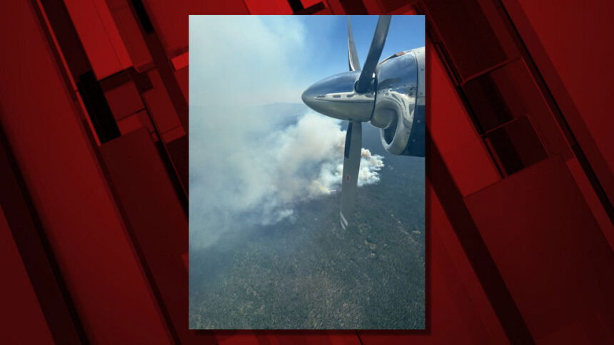
A break in weather and recent smoky skies allowed for an infrared flight and led to a reduced acreage figure for the fire being fought by about 175 firefighters five miles west of Elk Lake in the Three Sisters Wilderness Area.
Here's the Thursday morning update from fire officials.
Petes Lake Fire
Announcement - 08/31/2023
Petes Lake Fire Update – August 31, 2023 – 10:00 a.m.
Deschutes National Forest and Willamette National Forest
Fire Information: (541) 801-3564 Email: 2023.Peteslake@firenet.gov
Inciweb: https://inciweb.nwcg.gov/incident-information/orwif-petes-lake-fire
Facebook: www.facebook.com/PetesLakeFireInfo
Resources: 173 Total Personnel | 3 Hand Crews | 1 Dozer | 4 Helicopters | 6 Engines
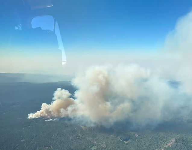
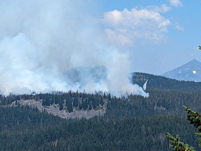
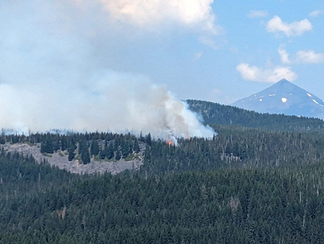
Central Oregon – The Petes Lake Fire was started by a lightning strike on Friday, August 25, along the border of the McKenzie River Ranger District of the Willamette National Forest and the Bend Fort-Rock Ranger District of the Deschutes National Forest in the Mink Lake Basin area of the Three Sisters Wilderness. The fire is burning five miles west of Elk Lake and is 318 acres in size. An overnight infrared flight has resulted in more accurate mapping data.
The Petes Lake Fire is burning in a rugged and difficult to access Wilderness area and although smokejumpers and hotshot crews made progress through direct attack during the incident's initial stages, continued direct attack on the fire poses a very high risk to firefighter safety without a significant probability of success.
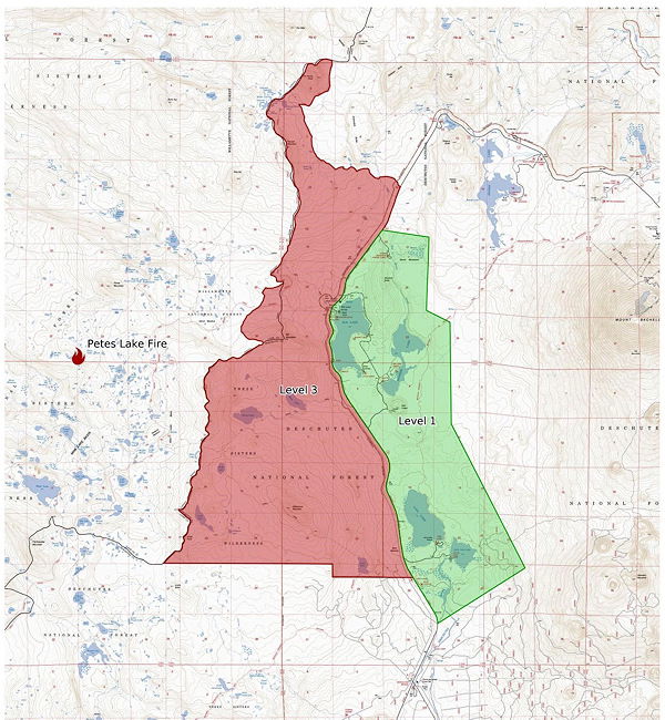
The primary objectives on the Petes Lake Fire are public and firefighter safety, followed by protecting values at risk, and confinement of the fire to the west of the Cascades Lake Highway and within the Wilderness area.
Fire managers will focus on the Cascades Lake Highway, identifying and strengthening control features. Infrastructure and other improvements near the highway will be evaluated and protected as needed. Because the majority of our current efforts will be focused in areas that are not directly on the fireline, success on this fire will be measured by meeting the primary objectives rather than by containment percentage.
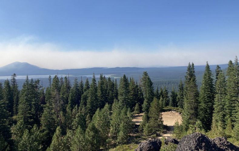
Yesterday: Two hand crews, supported by a dozer, prepped and continued creating a shaded fuel break on the west side of the Cascade Lakes Highway. The gap in weather and smoke provided the opportunity for a successful reconnaissance flight over the fire and allowed fire staff to refine the map.
Today: Hand crews will continue working on the shaded fuel break along the highway. Resources to support the incident will continue to arrive. The structure protection group will continue to assess structures and develop structure protection plans.
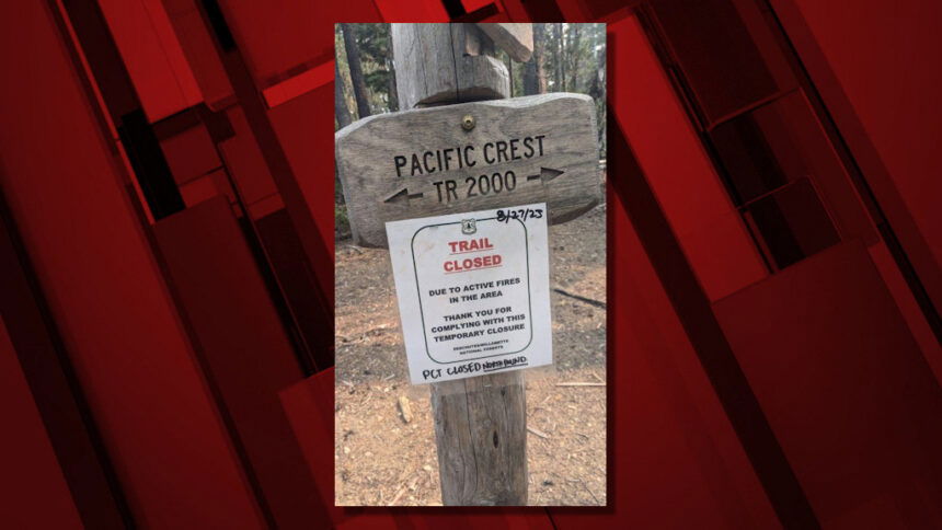
Closures: The closure order on the Willamette and Deschutes National Forests for the Petes Lake Fire remains in place and can be found here: fs.usda.gov/detail/deschutes/news-events/?cid=FSEPRD1134682.
Evacuation: Evacuation notices issued Sunday by the Deschutes County Sheriff remain in place: https://www.deschutes.org/sheriff/page/emergency-information.
Level 3 (Go Now) Evacuation notice is issued for all areas west of the Cascade Lakes Hwy from the Lucky Lake Trailhead north to the Mirror Lake Trail.
Level 1 (Be Ready) Pre-Evacuation notice is issued for areas around Elk Lake down to Little Lava Lake. This means “Be Ready” for potential evacuation. Be aware of danger in the area.
Level 2 – (Be Set) to evacuate at a moment’s notice. (There are no level 2 evacuations currently.)
Weather: Today, a low-pressure system will move in with the potential to bring intermittent rain for the next 48-72 hours. This system has the potential to generate thunderstorms on Friday and Saturday as well.
Earlier info:
Crews struggled with the air aspect of the effort on the day the fire was spotted, as thick smoke grounded aircraft.
"They had been unable to reach the fire Friday evening due to a smoke inversion that made the visibility impossible for our aircraft to fly," Olle said. "Once firefighters were on scene Saturday morning, they began initial attack efforts on the incident."
The Wanoga and Kapka sno-parks have been temporarily closed to the public while firefighters use them as support bases for their operations. Officials added that there is no threat from the Petes Lake fire to those two locations.
Meanwhile, on Monday morning, firefighters were called out to three small fires in the general area of Skyliners Road west of Bend and stopped forward progress on all three by early afternoon, officials said. The cause of the fires is under investigation, Deschutes National Forest Public Affairs Specialist Jaimie Olle said.
Due to fire activity in that area, the Tumalo Creek Trail was closed between Skyliners Lodge and the junction with the South Fork Trail.
The Willamette and Deschutes National Forests said Monday they were closing the area surrounding the Petes Lake Fire, effective immediately.
Due to very dry conditions and forecast warmer temperatures, firefighters anticipate increased fire activity. For the public’s safety, the two national forests are temporarily closing all trails within the boundary outlined in the map viewable below. Forest Service wilderness rangers were in the area, alerting anyone already camping within the closure area.
The following trails are temporarily closed:
- The Pacific Crest Trail is closed between the junction with Winopee Lake Trail (#16) and Elk Creek Trail (#3510) to the junction with Mirror Lakes Trail (#20).
- Willamette National Forest Trail Closures:
Bear Flat - #3301
Breezy Point - #3517
Buck Meadows - #3521
Elk Creek - #3510
Foley Ridge - #3511
French Pete - #3311
Goose Lake - #3542
Horse Creek - #3514
Horse Lake - #3516
James Creek - #3546
Lake Side - #3525
Louise Creek - #3520
Martin Way - #3525.1
McBee - #3523
Mink Lake - #3526
Nash Lake - #3527
Olallie - #3529
Olallie Mountain - #4100
Park - #3530
Porky Lake - #4338
Rainbow Falls - #3543
Rebel Creek - #3323
Rebel Rock - #3324
Red Hill - #3515
Separation Lake - #3536
Separation Meadow - #4331
South Fork - #3327
Starwano - #3537
Substitute Point - #4343
Sunset Lake - #3515.1
Water Holes - #3538
Wildcat - #3331
- Deschutes National Forest Trail Closures:
Horse Lake - #2
Island Meadow - #3
Senoj Lake - #14.1
Six Lakes - #14
Snowshoe Lake - #33
Winopee Lake - #16 (partially closed)
Here's Sunday's full DCSO notice:
A Level 3 (Go Now) Evacuation notice is issued for the following areas:
All areas west of the Cascade Lakes Highway from the Lucky Lake Trailhead north to the Mirror Lake Trail. This includes the areas around Lucky Lake, Leech Lake, Doris Lake, Blow Lake and Mirror Lakes.
Level 3: Means “GO” evacuate now. Leave immediately! Danger to your area is current or imminent, and you should evacuate immediately. If you choose to ignore this advisement, you must understand that emergency services may not be available to assist you further. DO NOT delay leaving to gather any belongings or make efforts to protect your home. This will be the last notice you receive.
A Level 1 (Be Ready) Pre-Evacuation notice is issued for the following areas:
Areas around Elk, Hosmer, Lava and Little Lave Lakes. This includes areas east of Cascade Lakes Hwy from Blue Lagoon north to Quinn Meadows.
Level 1: Means “BE READY“ for potential evacuation. Residents should be aware of the danger that exists in their area, monitor emergency services websites and local media outlets for information. This is the time for preparation and precautionary movements of persons with special needs, mobile property and (under certain circumstances) pets and livestock. If conditions worsen, emergency services personnel may contact you via an emergency notification system.
This decision was made after consultation with fire managers and authorized by Sheriff L. Shane Nelson. We will continue to work with fire managers to ensure public safety and prevent conflicts between citizens and fire operations. We appreciate the cooperation and understanding of residents.
Follow the Deschutes County Sheriff’s Office on Twitter and Facebook for up-to-date information.
Current maps including evacuation areas can be found at: https://deschutes.org/emergency
For fire information, you can visit the Central Oregon Fire Information site at: www.centraloregonfire.org
Make sure you are registered for Deschutes Alerts to receive evacuation and emergency alert and warnings in your area by going to www.deschutesalerts.org
---
