Oregon fires update: 9 killed, 4,800 structures lost; Camp Sherman evacuation levels lifted
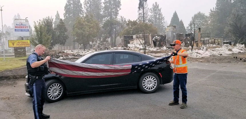

SALEM, Ore. (KTVZ) – The death toll in Oregon’s devastating wildfires rose by one, to nine on Saturday, while the number of still-missing people dropped to five and the count of destroyed homes, businesses and other buildings rose to about 4,800, the state Office of Emergency Management reported.
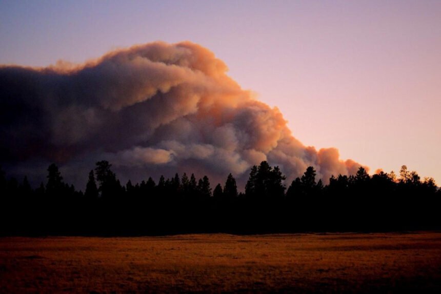
Meanwhile, the first rain in over a month, as well as cooler temperatures and firefighter progress on the nearly 200,000-acre Lionshead Fire west of Warm Springs allowed Jefferson County officials on Saturday to lift most Level 1 and 2 evacuation notices for the Camp Sherman area.
The only exception to lifting of the 2-week-old evacuation notices is a continued Level 1 “Be Ready” notice for structures along Forest Service Road 1499 to Monty Campground, Jefferson County Frontier 911 dispatchers said in a notice. They also advised residents that there are “still Forest Service area closures in place for safety reasons.”
Here is the Oregon Department of Forestry information summary for Saturday:
We are closely monitoring 10 major fires in Oregon, down from 17 originally (see table below for details). Fires are removed from the list when they are 100% lined and fire managers are confident in their progress toward containment. There are more than 7,500 personnel assigned to these fires, not including many of the government employees, landowners, forestland operators, and members of the community who are contributing every day. There have been resources from 39 states and multiple Canadian provinces in this fight alongside Oregonians. About 1 million acres have burned in Oregon since the start of this year, which is nearly double the 10-year average of approximately 557,811.
| Fire name | Acres burned (est.) | Containment | Location |
| Lionshead | 198,231 | 10% | 20 miles W of Warm Springs |
| Beachie Creek | 192,012 | 20% | 15 miles N of Detroit |
| Holiday Farm | 173,025 | 12% | 3 miles W of McKenzie Bridge |
| Riverside | 137,865 | 11% | 2 miles SE of Estacada |
| Archie Creek | 130,429 | 32% | 20 miles E of Glide |
| Brattain | 47,243 | 44% | 8 miles S of Paisley |
| Slater | 42,000 in Oregon | 10% | SE of Cave Junction (also in No. California) |
| S. Obenchain | 32,833 | 45% | 5 miles E of Eagle Point |
| Two Four Two | 14,473 | 49% | W/NW of Chiloquin |
| Thielsen | 9,536 | 18% | E of Diamond Lake |
Please note: The acres burned estimates above are based very limited information available. These numbers will change over the next several days, in some cases significantly. We will be taking every opportunity to map these fires. Fire maps are an important tool for both ongoing response operations and keeping people informed.
More information
- ODF wildfire blog and Significant Fire Potential Map
- Northwest Coordination Center – Regional Update and National Situation Report
- Inciweb (information on individual incidents)
Here are Saturday’s updates on major fires in the area:
Lionshead Fire
Widespread Rain Helps with Containment Efforts
Current Situation: A light rain fell on most parts of the fire yesterday and today, the first rain since the fire began on August 16, 2020. The rain should improve smoke conditions and will allow fire managers to fly the fire – providing a better view of current conditions and the opportunity for replacement of badly needed radio repeaters to improve communications. The rain itself is not enough to suppress the fire, but it can be a crucial element for the work.
High humidity and rain will limit the spread of the fire today, but heavy fuels and duff will continue to burn and hold heat.
Collaboration with firefighting efforts on the Beachie and Riverside Fires has created great opportunities for containment on the northwestern edge of the fire. Incident Commander Dan Dallas noted that the team “…picked up on the rhythm of the incident quite well on our first day.” A smooth transition is a testament to the communication between the departing team and the new team and the organizational structure the departing team created.
Firefighting Efforts by Division: (Refer to the map for division breakdown.)
Division A: There are a couple of small spot fires, but rain is helping to subdue them. Mop up continues. Most of Div A looks very good. There are a lot of snags toward Badger Butte, but other side has significant amount of good, direct dozer line on E side of the butte. Along Rt 84, the burnouts have worked well and crews are mopping up down toward the Div E break. Towards DP87, there was not a lot of activity or effort except for a small spot fire that will be prioritized today. Steep, rugged terrain and plenty of snags are present in the Badger Butte area. Direct dozer line was constructed up to Badger Butte back along the fire’s edge and was tied into road systems. On the Warm Springs reservation fire managers are looking at direct options to keep this fire as small as possible.
Division E & G: Lots of good solid black line in E and G activity is primarily mop up activity. This division is in patrol status which involves mopping up and securing the fire’s edge. Rain helped this effort and moderated fire behavior.
Division I, K, N: These divisions look really good. Mop-up and patrol status. Right down to the N/R break. Immediately to the west, there is a lot of lava rock. This is difficult to go direct on. For now, aircraft and UAS work will recon and look for opportunities for action. Further to the west, crews are tying their lines into the old burn in Div R. This section of the fire is in patrol and monitor status and is secured overall. Backhaul missions, which involve returning firefighting equipment to camp for use elsewhere, are occurring along this section of the fire. These divisions may be merged into one in the coming days as the east side of the fire continues to hold.
Division R: There are no crews on active edge of the fire in this division due to terrain and lava rock safety concerns. Fire managers are monitoring this area with aircraft and drones with IR capability as aviation conditions improve. Air support will monitor any fire spread.
Division S: A historic fire scar (Whitewater Fire) is allowing this division to construct hand and dozer line that can connect to existing road systems.
Division T: There is not much fire movement in this area, in part because this is probably the area that got the most rain. The steep rugged terrain and lack of resources have made this division difficult to attack directly. Structure protection in New Idanha, Idanha, Detroit, and South Detroit continues. Crews are securing the fire edge with a bulldozer. Spot fires are present and being contained.
Division W: Fire managers will scout for possible line activities.
Division Y: There was no activity other than a spot fire and a slop over along the 46 road. A priority is to keep this road open and contain fire spread east of the 46 road. This effort will continue today after crews were pulled due to lightning yesterday.
Division Z: – The priority in this division is suppression of a 600-acre spot fire. In coordination with the Riverside Fire, crews are working to connect road systems direct to the fire’s edge and where efforts will be successful.
Weather & Fuel Conditions: A strong low-pressure system will move inland today, creating rain and thunderstorms over the Lionshead Fire and the region. Thunderstorms may bring hail and heavy rain. Higher humidity will aid in firefighting efforts. Gusty winds may accompany thunderstorms. A warmer and drier trend will move in later this weekend with the possibility of rain mid-week.
Closures and Evacuations: Evacuation Notices remain in place for the Lionshead Fire. Level 3 “Go!”evacuation notices were issued for the communities of Detroit, Idanha, and Breitenbush. The Warm Springs Police Department, with assistance from the National Guard, is maintaining the Level 1 “Get Ready” evacuation notice for the Sidwalter area, including Miller flat and the for the half mile east of Highway 26 between mile markers 91.5 and 99, and a half mile east and west of the Highway between markers 99 and 100.
Roads and trails near the fires remain closed for public safety. This includes roads and trails on the Confederated Tribes of Warm Spring lands adjacent to the fire and a 40-mile section of the Pacific Crest Trail between Santiam Pass and Olallie Lake. Forest closures are in place for Deschutes, Mt. Hood and Willamette National Forests: Deschutes NF Alerts Willamette NF Alerts Mt. Hood NF Alerts.
Temporary Flight Restrictions: A Temporary Flight Restriction is in place over the Lionshead Fire and surrounding fires. Wildfires are a No Drone Zone. If you fly, we can’t. Whenever a drone is spotted near the fire all aircraft are grounded until we can be sure the drone is clear of the area. For more information, visit knowbeforeyoufly.org.
| Lionshead Fire Statistics: Size: 198,231 acres Containment: 10% Total Personnel: 1015 Location: 14 miles west of Warm Springs Reported: 8/16/20, approximately 8:44 p.m. Cause: Lightning | For More Information: Information Office: 971-277-5075, 8 a.m. to 8 p.m. Email: 2020.lionshead@firenet.gov InciWeb: https://inciweb.nwcg.gov/incident/6906/ Facebook: facebook.com/LionsheadFire |
Two Four Two Fire
September 19, 2020 10:30 a.m.
Oregon Department of Forestry IMT 2
Bill Hunt, Incident Commander
Email contact—twofourtwofire.information@gmail.com
Public Information Line: (541) 846-8174
Inciweb—https://inciweb.nwcg.gov/incident/7159/
Facebook—https://www.facebook.com/TwoFourTwoFire/
Size: 14,473 Acres
Containment: 49%
Start Date: Sept. 7, 2020
7:00 p.m.
Expected
Containment Date: Sept. 25, 2020
Location: Northwest of Chiloquin, Oregon
Cause: Unknown
Est. Cost: $5.6 million
Personnel: 413
Resources: 8 hand crews
27 Engines
6 Dozers
11 Water Tenders
Aircraft: 3 Helicopters
Evacuations: None
Structures
Threatened: 0
Structures
Damaged: 33
Structures
Destroyed: 48
Closures: None
Fire Summary:
Great progress was made yesterday as crews are getting close to meeting
the 100 foot depth of blackened perimeter around the fire. In some areas crews have gone beyond the 100’ to eliminate visible smokes that are well into the interior.
One of today’s goals will focus on locating hazard trees and removing them. Snags pose a threat to firefighter’s safety as well as public safety. Crews will continue removing hazards around homes, including snags and hot spots.
Weather will remain slightly cooler today over the fire. We did not receive the rain that was expected yesterday. But nonetheless, cooler weather significantly helps in suppression efforts with higher humidity and lower temperatures keeping fire activity low. Tomorrow, warmer weather is expected which will help firefighters identify hot spots. With a warm up in the weather any hot spots that have not been extinguished will show themselves during the late afternoon hours.
Firefighter and public safety is the priority during this incident, including
COVID mitigation. Personnel will be following Center for Disease Control guidelines to limit personal interactions both within camp and with the local community. The incident command post and fire camp are closed to the public and media.
BRATTAIN FIRE UPDATE
September 19, 2020 @ 9 AM
Yesterday:
After five consecutive days of Red Flag conditions, a frontal passage brought erratic winds, but cooler temperatures and increased humidity. No precipitation was received but crews were able to stop the forward progression of the fire in the northwest and southeast corners last night. This was accomplished with the support of eight helicopters, Crews finished mopping up along the northeast quadrant of the fire; all resources were moved to other priority areas. Crews and heavy equipment continued to widen and strengthen lines and conduct hoselay operations in the south and suppress a few hot spot fires near Clover Flat Road. A local timber company constructed a contingency line tying into the Ben Young burn scar. Crews will continue to look for hot spots and continue mop-up operations.
Today:A virtual community meeting will be live tonight, Saturday, September 19th at 7 pm on the Fremont-Winema National Forest Facebook page or on KPAI 103.1 FM. Topics include: summary of operations, weather and evacuation updates.
While the weather is more favorable, anticipate another active fire day today. The east will be in patrol status; access roads will be open to allow for resource advisors to assess rehabilitation strategies. Heavy equipment will continue to improve contingency lines and look for hot spots along the south flank of the fire where fire was seen creeping and smoldering yesterday; northwest winds will test these lines today. Expect to see several aircraft working the fire. Crews will be seizing opportunities to increase fireline construction and containment with the favorable weather over the coming days.
Latest evacuation information – including map – for the Brattain Fire outside Paisley from the Lake County Sheriff’s Office:
Level 3
· Clover Flat Road from Valley Falls east to Moon Ranch.
Level 2
· Highway 31 from Summer Lake Store south to Red House Lane (north of Paisley), all of Paisley, continuing south on Highway 31 to Valley Falls/the junction with U.S. Hwy 395.
· Clover Flat Road from the intersection with Hwy 31 (Beachler’s Corner) south to Murphy Ranch.
Level 1
· From Summer Lake Store north along Highway 31 to the top of Picture Rock Pass.
· Valley Falls approximately 5 miles south on Hwy 395 to Chandler State Park.
The Brattain Fire continues to be active on the north and southeast sides due to erratic winds. If you don’t need to be in the area, please leave now.
Highway 31 is open, but prepared for traffic congestion, delays and increased fire traffic. Please use caution driving in the area.
The Red Cross has an evacuation area at the Lake County Fairgrounds in Lakeview (1900 North 4th St.). There is fire information there as well.
Forest Closure: From Forest Road 29 southeast to Forest Road 3510 and the 28 Road east, all National Forest System lands and facilities are closed per Forest Closure Order 06-02-03-20-03. Forest Road 3315 is closed; the 28 Road is open.
Summary: The Brattain fire started on September 7th, 2020 and is currently burning on the Paisley Ranger District of the Fremont-Winema National Forest. The Eastern Area Incident Management Team is currently managing the fire. Firefighting crews continue to operate on a 24-hour schedule and are battling winds, extremely dry conditions and shortages of firefighting resources.
SIZE: 47,243 acres
CONTAINMENT: 44%
CAUSE: HumanPERSONNEL: 437
FIRE INFORMATION:541-947-6243
2020.brattain@firenet.gov
INCIWEB:inciweb.nwcg.govsearch “Brattain Fire”
Facebook: facebook.com, search:Fremont-Winema National Forest @R6FWNFSouth Central Oregon Fire Management Partnership @SCOFMPFIREINFO
BEACHIE CREEK FIRE UPDATE – September 19, 2020
Acres: 192,531 acres Percent Containment: 20%
Start Date: August 16, 2020 Cause: Under Investigation
Origin Location: Opal Creek Wilderness: Fuels: Timber and logging slash
two miles south of Jawbone Flats, six miles north of Detroit, Oregon.
Resources: 664
Firefighters Make Good Progress with Improved Weather Conditions
Smoke lifts, improving air quality and visibility.
Salem, Ore. – Rainfall over the last 24 hours decreased fire behavior and allowed firefighters to make a lot of progress securing the perimeter of the Beachie Creek Fire. This amount of precipitation does not put the fire out. Smoldering, small flames, and smoke will continue to be observed throughout the fire area. The emphasis for firefighters remains on protecting communities to the south and west of the fire. Firefighters continue to strengthen the lines around Scotts Mills, Stayton, Lyons, Mill City, and Detroit. Other crews continue to put in line to protect timber investments on the north side of the fire near Scotts Mills. Firefighters will continue to monitor the area for hazards related to precipitation.
As smoke lifted, visibility on the fire improved. This will allow firefighters to utilize aircraft and to better assess certain areas of the fire. For the safety of firefighters and so that they can continue with air operations, the public is reminded that “If you fly, we can’t.” There is a temporary flight restriction around the entire area of the fire.
The Incident Command Team continues to address infrastructure and community needs by assisting power companies, insurance companies, and communication firms. The Team is providing these organizations with information, logistics, and transportation support. This work is important for residents and community members returning to the area.
Fire officials also continue to work closely with the Marion County and Linn County Sheriff’s Offices, ODOT and the Oregon State Police to coordinate residents’ return to Santiam Canyon. Currently 1,118 structures are at Level 3 evacuations and another 4,574 are in level 2 evacuations. As more residents are allowed back into the area, it is imperative that everyone heeds road closures and safety messages. Anyone who enters the fire perimeter jeopardizes firefighting operations and puts lives at risk.
Lingering showers are predicted through most of Saturday, ending in the evening. Minimum relative humidity levels will generally be above 60% across the fire area. High temperatures will range from upper 50s to upper 60s. More precipitation is not expected for the next few days, but temperatures will remain cooler and overnight relative humidity will increase which is typical for this time of the year.
The Willamette National Forest, Bureau of Land Management, and State lands around the fire remain closed to the public. Go to InciWeb (link below) for more information about closures in the area.
| Public Contact Information: Facebook: facebook.com/BeachieCreek E-mail: BeachieCreek@gmail.com Phone: 541-583-0526, 8 a.m. to 8 p.m. | Inciweb https://inciweb.nwcg.gov/incident/7001/ Smoke and Air Quality http://oregonsmoke.blogspot.com/p/air-quality-now.html https://wildlandfiresmoke.net/outlooks |
